Fourth stop. Let us rediscover the Old Continent – Europe.
Alhambra


Alhambra simply means “red”. The fortress in Granada, Spain, was built between 1232 and 1273 and was extended until the 14th century during the reign of the emirs of the Nasrid dynasty. The former stronghold of the Moorish caliphs remembers the Arab rule of the Iberian Peninsula. Beautiful courtyards, gardens with flowing water, balconies, and ornaments with verses from the Koran are famous. The building complex was consumed by great fires, including the largest one on September 15, 1890.
City of Venice


(Venezia, Venesia or Venexia) The name comes from Veneti people, who were inhabiting that’s region in 10th century. city in Italy (Northeastern part) and the capital of the Veneto region. City itself is stretched out on a group of 118 small islands that are separated by canals but connected by over 400 bridges. Nevertheless, the fastest way of traveling are gondolas. For over thousand years (697 to 1797) the city was the capital of the Republic of Venice. It was a major financial and maritime power during the Middle Ages and Renaissance, as well as an important center of trad. The merchants were specialized in selling especially silk, grain, and spice, and of art. The city-state of Venice is believed to be the first real international financial center, rising somewhere in the 9th century, and reaching its greatest reputation in the 14th century. This made Venice a wealthy city throughout most of its history, which was translated to beautiful palaces, building bridges and churches. Seme architectural examples includes: St. Marks Basilica; Doge’s Palace; Venetian Arsenal; Basilica di Santa Maria della Salute; Palazzo Contarini del Bovolo; Loggetta del Sansovino; Casa dei Tre Oci, and many, many more.
Kremlin and the Red square


Fortified buildings complex in the center of Moscow. It is most recognizable by the kremlins (Russian citadels), with their colorful tops, but there is much more to it. Five palaces (Grand Kremlin Palace that was formerly the Tsar’s Moscow residence) four cathedrals, all surrounded by the Kremlin Wall with Kremlin towers. The complex now serves as the official residence of the President of the Russian Federation. The site of Kremlin was inhabited since 2nd century BC, and almost from the beginning it was associated with the ruling group. Previous wooden constructions were destroyed during raids and sieges. The modern place, in the form that we all know today, was constructed (over the previous wooden remnants) somewhere between 1585 – 1495, by Grand Prince Ivan III. He brought the best architects and skilled masons from Italy (which was already high in Renaissance epoque). During the Imperial period, from the early 18th and until the late 19th century, the Kremlin was heavily rebuilt, updated (according to present standards). After the revolution of 1917, both Lenin and Stalin, stripped the residence of most of its Imperial splendor. The kremlin eventually was closed for the public, till in 1955 Nikita Khrushchev, brought it back to public life, and started much needed restorations. Today, you cannot imagine postcard from Moscow without those brightly color towers.
Mont – Saint Michel


is a tidal island and mainland commune in Normandy, France. Home of the monastery. The island itself lies approximately one kilometer (0.6 miles) off the country’s northwestern coast, at the mouth of the Couesnon River near Avranches. Its size reaches only 7 hectares (17 acres) in land space. The mainland part of the commune is 393 hectares (971 acres) in area so that the total surface of the commune is 400 hectares (988 acres). The island lays just a few hundred meters from land. It is accessible at low tide to the many pilgrims to its abbey, but extremally secure as an incoming tide cuts off all the ways out, leaving any possible attackers on the mercy of the Mother’s nature. Louis XI recognized the reverse benefits of its natural defense and turned it into a prison. The abbey was used regularly as a prison during the Ancien Régime (political and social system of the Kingdom of France from the Late Middle Ages until the French Revolution of 1789, which led to the abolition of hereditary monarchy and of the feudal system of the French nobility). Mont Saint-Michel and its bay are on the UNESCO list of World Heritage Sites.
West Norwegian Fjords, Norway


What is a Fjord, you may ask? Well, it is long, narrow bay with steep sides or cliffs, created by a moving glacier. The west Norwegian Fjords are 2 connected places, separated from each other by about 74.5 miles (120 kilometers). The regions of Geirangerfjord and Nærøyfjordtotal have together 122 712 hectares (111 966 ha on the land and 10 746 ha in the sea). Geirangerfjord is 9.3 miles (15 kilometers) long, with the maximal width of width 0.93 mile (1.5 kilometers); where the Nærøyfjordtotal is 11 miles (18 kilometers) long and only 16 feet (500 meters) wide. The two areas have a similar climate. Snow stays from October to the end of May in the mountains and the end of November to March in the valleys. They are easily accessible by boats. He picturesque landscapes, is something worth seeing at least one in a lifetime.
Plitvice Lakes National Park


The national park was founded in 1949, which make it the oldest one in Croatia. The protected area reaches over 73,350 acres (296.85 square kilometers). The location is mostly famous for its cascading lakes. Sixteen of them, to be exact. All the lakes are all interconnected and follow the water flow. They are separated by natural dams of travertine (limestone deposit made by mineral and hot springs; usually milky white in color; very characteristic). From the top, the lakes are descending from an altitude of 2,087 to 1,650 feet (636 to 503 meters) over about 5 miles (8 kilometers). The lakes as a group cover an area of about 0.77 square miles. What is extremally characteristic about all the lakes, it is their color, ranging from azure to green, grey, or blue. The colors change constantly depending on the quantity of minerals or organisms (algae) in the water and the angle that’s sun is shining on them.
Historic Centre of Kraków


The city of Kraków, is the old capital of Poland (second one from the 3). It was the center of Poland’s political life from 1038 until 1596 (King Sigismund III Vasa relocated his court to Warsaw). During Medieval times Kraków was surrounded by a 1.9 mile (3 kilometer) defensive wall complete with 46 towers and seven main. The current architectural plan of Stare Miasto (The Old City – the 13th-century merchants’ town) – was designed in 1257 after the destruction of the city during the Tatar invasions (1241, 1259, 1287). The district showcases the centrally located Rynek Główny (Main Square), the largest medieval town square of any European city. There are many historic landmarks in its surrounding area: St. Mary’s Basilica (Kościół Mariacki); Church of St. Wojciech (St. Adalbert’s); Church of St. Barbara; kamienice (row houses) and noble residences; Sukiennice (Renaissance cloth hall); Wieża ratuszowa (Town Hall Tower). And finally, the greatest ones: the Wawel Hill complex (the royal residence together with the Wawel Cathedral where several kings of Poland are buried), and the town of Kazimierz. For Polish people Kraków was and is till this day a city of arts and, a place where East and West are meeting. During WW II, the city was almost completely spared, and thanks to that is all the amazing architectural pearls survived.
Amalfi Coast


the history of it goes back to the 10th century when it started as a Duchy of Amalfi (fully independent state) in Italy. The coast comprises 11,231 hectares, and its main feature are steep hills, with not a lot of room for the farmland. The Amalfi Coast is a perfect example of a Mediterranean climate, featuring warm summers and mild winters. The picturesque houses, almost stack on top of each other, brings lots of tourists every year to this region. The main export product, created directly here, is Limoncello (bright yellow, lemon liquor)
Paphos (Pafos)


According to the Classical Greek Mythology, Aphrodite, the goddess of love and beauty, was born in the sea, and the site of Paphos, in modern Cyprus, was the place where she emerged into the dry land. But long before the Hellenic (Ancient Greeks) times, at this site in the Neolithic period (6th millennium BCE), worship of fertility deities has begun. Paphos was the site of one of the oldest Mycenean settlements. In the 12th century BCE, where they built a temple (dedicated to Aphrodite). The archeological site includes the remains of the villas, palaces, fortresses, and rock-hewn peristyle tombs. The villas were richly adorned with mosaic floors, with motifs representing themes from mythology and from everyday life. These mosaics, considered by archaeologists and recognized UNESCO to be amongst the finest in the world, through the history from the Hellenistic to the Byzantine period.
Altamira Cave


site was discovered in 1868 by Modesto Cubillas, and it turned out, to be one of the most important discoveries. Located in Cantabria, Spain. The cave is almost 3300 feet (1,000 meters) long and contains of a series of curved passages and chambers. The Altamira Cave holds examples of wall (rock) painting from the Upper Paleolithic period (35,000 to 11,000 BC). These paintings include abstract shapes as well the animal subjects. Buffalos, horses, goats, as well as handprints that were created when artists placed their hands on the cave wall and spray pigment over them to create a negative impressions. The caves remained extremely well-preserved because, because approximately 13,000 years ago a rockfall sealed the cave’s entrance, preserving its contents until its eventual discovery in 1868, as well the inner climate in the cave, was not in the contact with weather conditions on the outside.
Cinque Terre National Park


The coastline surrounding the five villages (Monterosso al Mare, Vernazza, Corniglia, Manarola, and Riomaggiore), and the surrounding hillsides are all part of the Cinque Terre National Park. It is the oldest park in Italy, the smallest as well, only at 4,300 acres exterior, but also one of the densely populated, with 5000 permanent residents in those five coastal towns. The Cinque Terre area is a popular tourist destination in Italy. Over the centuries, people have built balconies on the rocky, steep landscape right up to the cliffs that overlook the Ligurian Sea. The views of the houses on the sides of the hill, is truly spectacular. Even though the location in under the control of Mediterranean climate, there are still differences in landscape (due to existence of microclimate). The hills are covered with greenery: pine, Aleppo pine, corks, chestnut, samphire, sea cineraria, shrub rosemary, thyme, helichrysum and lavender, and succulents. The hill is as well a home to some species of birds and land creatures: gull, peregrine falcon, raven, dormouse, weasel, mole, badger, marten, fox and wild boar, wall lizard, rat snake, the grass snake of Aesculapius, viper; frogs and salamanders.
Stari Most (Old Bridge) of the Old City of Mostar


The bridge, on the territory of modern Bosnia and Herzegovina) was commissioned by Suleiman the Magnificent and completed in 1566/67. It was a magnificent example if Ottoman (During the 16th and 17th centuries, at the height of its power, under the reign of Suleiman the Magnificent, the Ottoman Empire was a multinational, multilingual empire controlling most of Southeastern Europe, Central Europe, Western Asia, parts of Eastern Europe, the Caucasus, Northern Africa, and the Horn of Africa) craftsmanship, that it was connecting two sides of Neretva river, was. During the Bosnian War (1993), it was intentionally destroyed by the Croatian Defense Council. After the war, the bridge was rebuilt using traditional construction methods and local materials and reopened in 2004.
Historic Center of Vilnius


Vilnius is one of the largest surviving medieval old towns in Northern Europe. The entire area of 887 acres (3.59 square kilometers), includes 74 quarters, with 70 streets and lanes numbering 1487 buildings. The oldest part of the Lithuanian capital of Vilnius, it has evolved over many centuries, of constantly changing cultural influence. This city is an example, of the greatest architectural styles—gothic, renaissance, baroque, and neoclassical—stand side by side and complement each other. Vilnius was the political center of the Grand Duchy of Lithuania (intricately connected to Poland) from the 13th to the end of the 18th century. The historic center on the city, is situated around the Vilnius Castle Complex (three castles, the first one dating back to around 1000 CE) and the area that was previously (Middle Ages) encircled by a wall. The circular street plan is starting out from the original castle site. Despite turbulent history (invasions and partial destruction), the city has been able to preserve many buildings, in Gothic, Renaissance, Baroque, and Neoclassical styles. Historic sites include: the Vilnius Cathedral in Cathedral Square, the Town Hall, the Vilnius University complex, Presidential Palace, Slushko Palace, Radziwiłł Palace, Tyzenhaus Palace, Vilnius Castle Complex with the Gediminas Tower and Royal Palace, St. Anne’s Church, St. Nicholas Church, All Saints Church, Gate of Dawn, Three Crosses, Cathedral of the Theotokos, House of the Signatories, Fragments of the Vilnius city wall, Vilnius dungeons. This is a site especially close to my heart because my family (my maternal side), lived there for generations.
Lake district


Famous for its scenic landscape of mountains, lakes, houses, gardens and parks, the Lake District was celebrated through picturesque and romantic visual arts and literature from the 18th century. Till today, this is a popular English holiday destination, with charming lakes, forests, hills, and mountains. he places is intricately connected with many English poets and writers, describing its peaceful beauty, or searching for inspiration among the green hills, for example: with William Wordsworth and other Lake Poets and with Beatrix Potter and John Ruskin. the Lake district is highly populated, with many permanent settlements, spread out throughout the whole territory. Some of the well-known feature include hills: Scafell Pike (978 m – 3,209 ft); Scafell (965 m – 3,166 ft); Helvellyn (951 m – 3,120 ft); Skiddaw (931 m – 3,054 ft); Valleys: Dunnerdale, Eskdale, Wasdale, Ennerdale, the Vale of Lorton, Buttermere valley, the Derwent Valley, Borrowdale, Ullswater valley, Haweswater valley, Longsleddale, the Kentmere valley, Grasmere, Great Langdale, Little Langdale, Coniston Water valley. Oak forest gives a home and shelter to local fauna.
Giant Causeway


an area on the north coast of Northern Ireland, of about 40,000 interlocking basalt columns. They creation is the result of an ancient volcanic fissure eruption, which means basically direct volcanic vent through which lava erupts, mostly without any explosive activity. The vent is often a few meters wide and may be many kilometers long. It was proclaimed national nature reserve in 1987 The tops of the columns form boulders (steps like) that take the lead from the cliff foot and disappear under the sea. Most of the columns are hexagonal (they have 6 sides), even though there are also some with four, five, seven or eight sides. The tallest ones reaching 39 feet (12 meters) high, and up to 92 feet (28 meters) the solidified lava in some parts. According to Irish legends and old Gaelic Mythology, the Causeway was built by the giant Fionn mac Cumhaill across the North Channel.
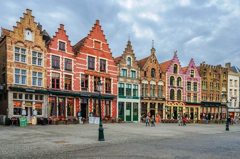
La Grande Place (Grote Markt)


“Grand Market” is the central square of Brussels, Belgium. The square measures 223 by 361 feet (68 by 110 meters). It is surrounded by magnificent guildhalls and two larger structures, the city’s Town Hall, and the King’s House (Breadhouse) that is a home to the Brussels City Museum. Since the 10th century, the square center of the town, was attracting merchants, becoming the most important part of the trade. With the beginning of the 13th century, three indoor markets were built on the northern edge of the Grand Place: a meat market, a bread market, and a cloth market. These buildings allowed the products to be showcased even in bad weather, but also allowed the Duke (Duke of Brabant) to collect taxes. The town Hall and the Kings House were built, as an additions in 14th and 15th centuries. On 13 August 1695, the Grand place and its marketplaces were destroyed in the large fire, cause by French army (bombardment of Brussels). It was rebuild a few years after that. Unfortunately, the European history, was not very peaceful, so the Grand Market place has its share in more destructions, wars, and natural disasters. Finally, in the 20th century, 19 November 1959 was the last day as the market square. The guild houses were converted into modern shopping centers, and till day, the Grand Place, is exceedingly popular tourist actions.
Meteora


Located in central Greece. It is the place where complex of 24 Eastern Orthodox monasteries, is build, in a very daring way. Meteora is a rock formation of sandstone peaks, hosting 24 Orthodox monasteries. According to the most popular theory, about 60 million years ago there was a seabed here and the mouth of a large river. Stone cones were to be created because of the deposition and accumulation of stones, mud, and sand in the river delta. The current shapes are to be the result of geological changes and erosion that have been subjected to millions of years. However, geologists cannot completely explain the unusual form of rock pillars rising rapidly from the ground and reaching a height of over 1968 feet (600 meters) above sea level. The caves in the surrounding area of Meteora, which were once continuously inhabited (from 50,000 to 5,000 years ago), are also the result of erosion and the influence of water, sun, and wind. The most famous of these is the Theopetra cave, where during the Ice Age (23,000 years ago) the former inhabitants built a stone wall, two-thirds protecting the entrance. It is the oldest man-made structure. In the period from the 14th to the 16th century, 24 monasteries were built, each on a separate rock. Currently, 6 of them are inhabited and open to the public. These are four male monasteries: Great Meteoron, Varlaam, St. Nicholas Anapausas( the Resting), Holy Trinity – and two female monasteries: St. Stephen and Rousanou.
The Royal Salt Mines in Wieliczka and Bochnia


The zones around Wieliczka and Bochnia, in Poland, contain deposits of rock salt, which has been mined since the 13th century. The two mines in Wieliczka and Bochnia are one of the oldest rock salt mines in the world and the longest operating industrial plants. From time ancient times, salt was evaporated from naturally occurring salty springs here. The drying up of these springs prompted people to search for salt beneath the earth’s surface. The first lumps of rock salt were reached by Hungarian miners brought to Poland in 1251 by the Hungarian princess and Polish queen Kinga of Arpada. Hundreds of kilometers of tunnels in both mines illustrate the development of mining technologies in Europe. They also include works of art, such as sculptures carved in salt and underground chapels. The three-kilometer-long tourist route leads through several of the 20 large chambers open to the public. The Wieliczka salt mine, has nine accessible levels with depths ranging from 64 (210 feet), and it being the first one, nineth level at 135 meters (1073 feet). In addition to serve as a museum and tourist attraction, the salt mine is a witness to religious celebrations, there are also various concerts, especially classical music, mining celebrations, competitions, and sports events, as well as exclusive New Year’s Eve balls and private events.
Semmering Railway


The Semmering railway was built in Austria between 1848 and 1854. It was the first mountain railway in Europe built with a standard track, and it is commonly referred to as the world’s first true mountain railway. Given the incredibly challenging terrain and the major altitude difference that was mastered during its construction of 25 miles (41 kilometers) of tracks through rugged mountains. The construction features 14 tunnels (among them the 1,431 m hilltop tunnel), 16 viaducts (quite a few two-stories one) and over 100 stone arch bridges and 11 small iron bridges. The stations and the buildings for the supervisors were often built directly from the waste rock dug out when making the tunnels. This project was undertaken in the early days of railway construction and required several innovations, but hank to them, thill this day, the Semmering Railway is the tunnels, viaducts and other works are still in use today. It is still fully functional as a part of the Southern Railway which is operated by the Austrian Federal.
Acropolis


The structure stands on a steep hill (citadel – fortified center of the city) above the city of Athens in Greece. Originally a fortification, it gradually developed into a religious sanctuary, associated with the cult of the goddess Athena (the Goddess Patron of the Athenians). In the 5th century BCE, following their victory over the Persians, the Athenians under Pericles constructed many monuments including the Parthenon, the Erechtheion, the Propylaia, and the Temple of Athena Nike. Throughout the history, the temple on the hill changed its purpose (under conquerors influence): under Byzantine rule, it was used as a church (under Virgin Mary patronage); in Ottoman Times it serves as a Mosk. Nevertheless, through the centuries, The Acropolis put on a profound influence on architecture and arts worldwide. In 1975, the Greek government started reconstruction and restoration project reverse the decay of centuries of erosion, pollution, destruction due from military use, and misguided past restorations. The plan was to use local stones, to keep the work and the materials as close to the original ones.
Rock Carvings in Tanum


In Sweden, near Tanumshede, Bohuslän, distinct area of 15.5 miles (25 kilometers) section, and about 51 hectares (126 acres or 0.5 square kilometers), is covered with rock paintings and rock carvings. long time ago, when the drawing was made, the region was part of the coastline, but today the site is located at an elevation of 82 feet (25meters). The petroglyphs carved on a granite bedrock originate from the Nordic Bronze Age (from about 1700 to 500 BCE). There are around 1500 known sites with carvings depicting humans, animals, weapons, tools, many of the glyphs depict boats carrying around a dozen passengers, Wagons or carts pulled by the animals. Other glyphs depict humans with a bow, spear or axe, hunting scenes, human at a plough drawn by two oxen pulling what might be a branch. They deliver the evidence of the life and beliefs of people who made them, and some settings were interpreted as primary contemporary centers for worship and cult. Some carvings, in our modern times, have been painted red, to make them more visible for tourists. This procedure brought a lot of criticism for removing the authenticity and original state of the drawings, in the name of profits.
Stonehenge

Located in southern England, it is comprised of roughly 100 massive upright stones placed in a circular layout. Stonehenge’s boulders, of which the largest weighs more than 40 tons and rises 24 feet, are arranged in the circle, with some of the rocks, placed vertically on top of the others.
While many modern scholars now agree that Stonehenge was once a burial ground, they have yet to determine what other purposes it served and how a civilization without modern technology—or even the wheel—produced the mighty monument. It is believed, that is the contruction was made in parts, and that the beginning of it starts 5000 years ago, or even more. Its construction is even more baffling because, while the sandstone slabs of its outer ring hail from local quarries, scientists have traced the bluestones that make up its inner ring all the way to the Preseli Hills in Wales, some 200 miles from where Stonehenge sits on Salisbury Plain.
Swiss Alps Jungfrau-Aletsch


This site includes one of the highest and most glaciated areas of the Alps in Switzerland, with peaks of Eiger, Mönch, and Jungfrau mountains, included in the frozen formation. The Jungfrau-Aletsch site is almost unchanged and untouched, except for trails and mountain huts. About half of the area is higher than 1.61 mile (2,600 meters). The total area covered by glacier is 35,000 ha, and it is the largest uninterrupted area of ice in the Alps. The largest and longest glacier in the Alps, the Aletsch Glacier is 1.4 mile (23 kilometers) long and has a maximum thickness of 0.55 mile (900 meters) at Konkordiaplatz. The locations deliver a structural record of the processes that shaped the High Alps. Glaciers and barren rock constitute 80% of the area; 6% is forested, 5.2% is alpine meadow, and 8% is scrub. Remarkably diverse habitat for animals and plants. Even though the harsh conditions, 1,250 fauna species have been recorded on the site, including 271 craniates: 42 mammals, 99 birds, eight reptiles, four amphibians and seven fish, and numerous invertebrates including 97 mollusks and 979 insects, so as you can see, it is not completely forgotten piece of land.
The landscape has played an important role in the development of mountaineering and alpine tourism, as well as in literature and in arts.