First stop. North American continent.
Mammoth Cave National Park
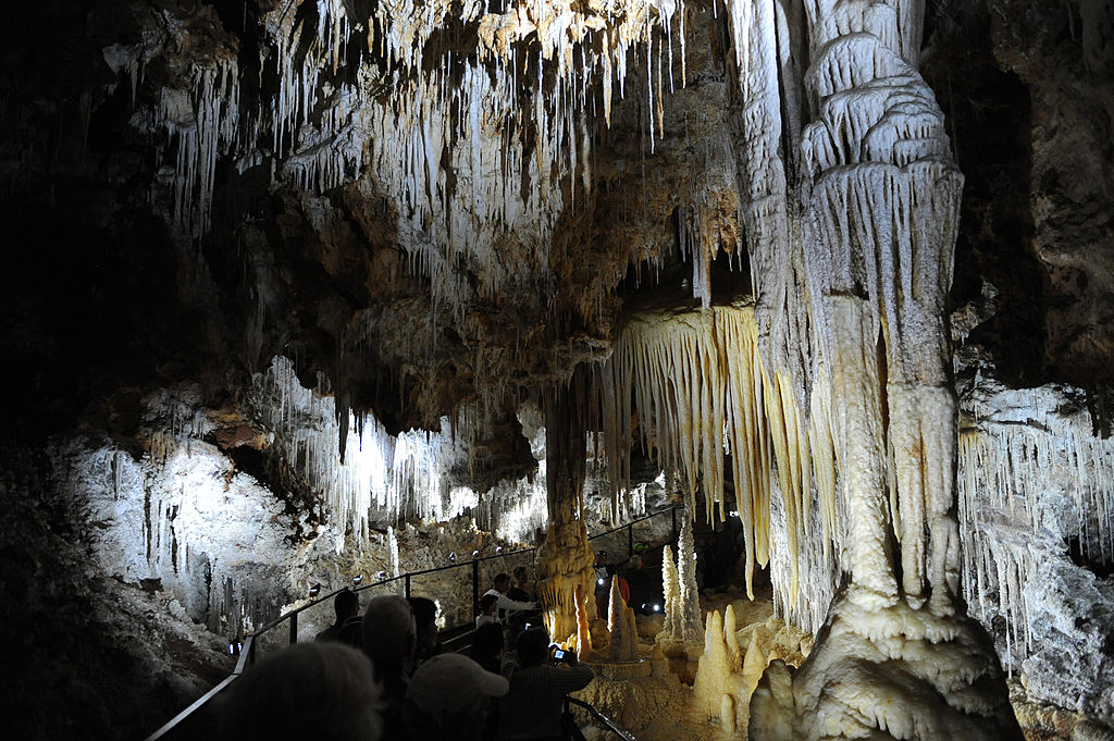
Mammoth Cave National Park preserves are the longest known cave system in the world. Located in part of the verdant, hilly Green River valley in south central Kentucky. The park was established as a national park on July 1, 1941, a World Heritage Site on October 27, 1981, with more-than 400 miles (640 kilometers) of caverns to explore, within park’s 52,830 acres (21,380 ha). The size of those enormous chambers and complex labyrinths, finally gave the park its name: Mammoth.
Yellowstone national park
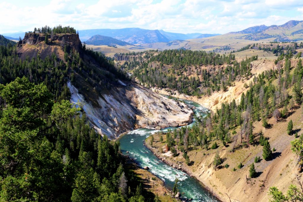
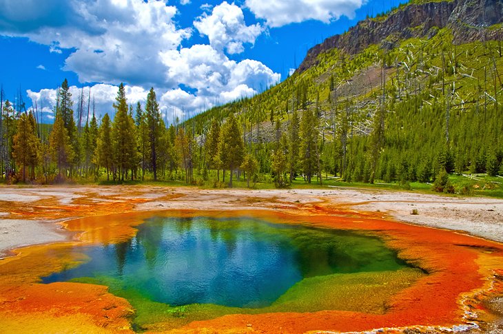
Located in the northwest corner of Wyoming and stretching into Montana and Idaho. It was founded by President Ulysses S. Grant and U.S. Congress on March 1, 1872. It was the first national park in the U.S. and the first national park in the world. The park is known for its wildlife and its many geothermic elements, especially Old Faithful geyser, one of its most popular. Yellowstone National Park covers an area of 3,468.4 sq mi (8,983 km2), consist of lakes, canyons, rivers, and mountain ranges. Yellowstone Lake is one of the largest high-elevation lakes in North America and is centered over the Yellowstone Caldera, the largest supervolcano (large volcano that has had an eruption with a Volcanic Explosivity Index (VEI) of 8, the largest recorded value on the index. This means the volume of deposits for that eruption is greater than 1,000 cubic kilometers (240 cubic miles)). on the continent.
Hawai’i Volcanoes National Park
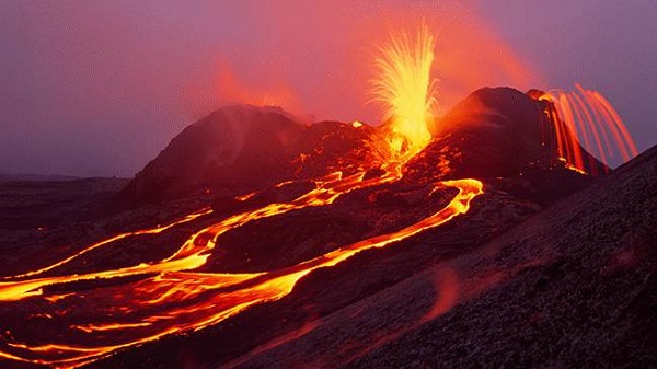
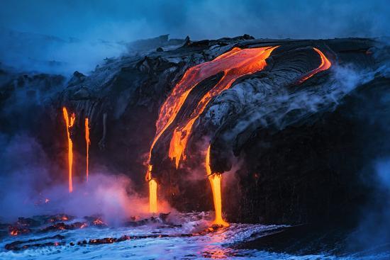
founded on August 1, 1916, on the island of Hawaii. The park covers 323,431 acres (505.36 sq mi; 1,308.88 km2) of land the park territory includes two active volcanoes: Kīlauea (one of the world’s most active volcanoes), and Mauna Loa (the world’s most massive shield volcano). The park provides scientists with insight into the birth and development of the Hawaiian Islands, and ongoing studies into the processes of volcanism. For visitors, the park offers breathtaking volcanic landscapes, as well as signs of rare flora and fauna.
Grand Canyon
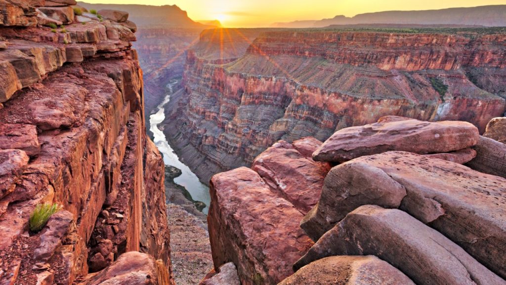
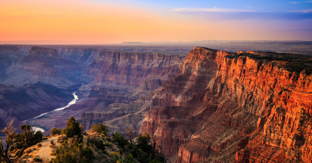
it is 15th (on the list) National Park to be created in United States. The park itself covers 1,217,262 acres (1,901.972 sq mi; 4,926.08 km2). The park’s central feature is the Grand Canyon, a valley of the Colorado River. The Grand Canyon, including its extensive system of river canyons, is valued for its combination of size, depth, and exposed layers of colorful rocks dating back to Precambrian times.
Yosemite national park
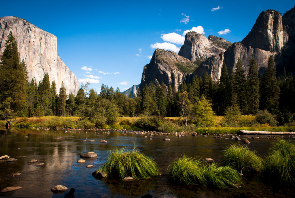
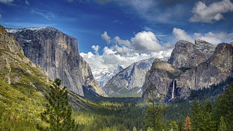
national park in the Central California, surrounded on the southeast by Sierra National Forest and on the northwest by Stanislaus National Forest. The park covers an area of 748,436 acres (1,169 sq mi; 3,029 km2). Yosemite is internationally recognized for its granite cliffs, waterfalls, clear streams, giant sequoia groves, lakes, mountains, meadows, glaciers, and biological variety. The park is roughly the size of the U.S. state of Rhode Island and contains thousands of lakes and ponds, 1,600 miles (2,600 km) of streams, 800 miles (1,300 km) of hiking trails, and 350 miles (560 km) of roads.
Pre-Hispanic City of Chichen-Itza
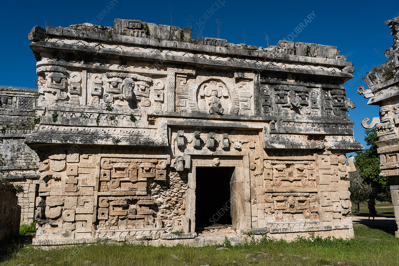
large city built by the Maya people of the ending of Classic period (c. AD 800–900). The site is in modern Yucatán State, Mexico. The site demonstrates an array of architectural styles (seen in central Mexico and the Northern Maya lowlands). Chichen Itza was one of the largest Maya cities, with closely grouped architecture of the site core covering an area of at least 2 square mile (5 square kilometers) and it believed to have been one of the mythical great cities. The city may have had the most diverse population in the Maya world, a factor that could have contributed to the variety of architectural styles at the site.
Rock Paintings of the Sierra de San Francisco
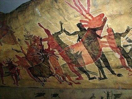
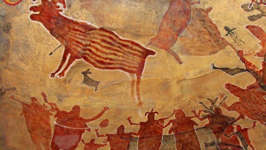
The pictographs on the walls of the caves, are most likely the artistic products of the Cochimi people in the Baja California peninsula. This group became extinct in the nineteenth century. eighteenth-century Jesuit missionaries collected lots of information about them, and in their written form they gave us all the information. There were some speculations that the paintings had meanings relating to hunting magic, religious practices, or ancestor worship, but there is no consensus on these interpretations. Animal species including deer, wild sheep, rabbit, puma, lynx, whale, turtle, fish, and birds are depicted. These paintings on the roofs and walls of rock shelters in the Sierra de San Francisco were first discovered by Europeans in the eighteenth century by the Mexican Jesuit missionary José Mariano Rotea.
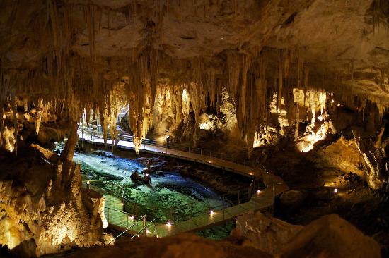
Dinosaur Provincial Park
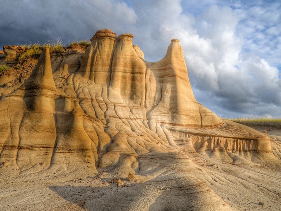
The park was established on June 27, 1955 is in the Red Deer River valley, which is well-known for its stunning landscape, and abundance of dinosaur fossils. In Fact, the park is well known for being one of the finest dinosaur fossil areas in the world. Fifty-eight dinosaur species have been discovered at the park and more than 500 specimens have been removed and exhibited in museums around the globe. The famous fossil collection, that is came from the park goes into nearly 500 species of life forms. So, no surprise, when on October 26, 1979 Dinosaur Park become World Heritage Site in 1979.
Pre-Hispanic Town of Uxmal
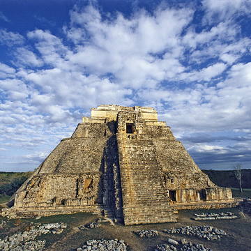
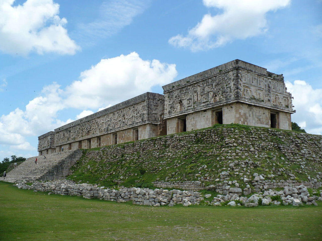
ancient Maya city of the classical period located in present-day Mexico. It is considered one of the most important archaeological sites of Maya culture. Its buildings are remarked for their size and decoration. Ancient roads called sacbes connect the buildings and were built to other cities in the area such as: Chichén Itzá (Mexico), Caracol and Xunantunich (Belize), and Tikal in (Guatemala). The buildings in Uxmal have smooth low walls that open on ornate murals based on representations of typical Maya huts. These are represented by columns and trapezoidal shapes. There is lots of entwined snakes; many representations of two-headed snakes as well, and feathered serpents.
Glacier Bay National Park & Preserve
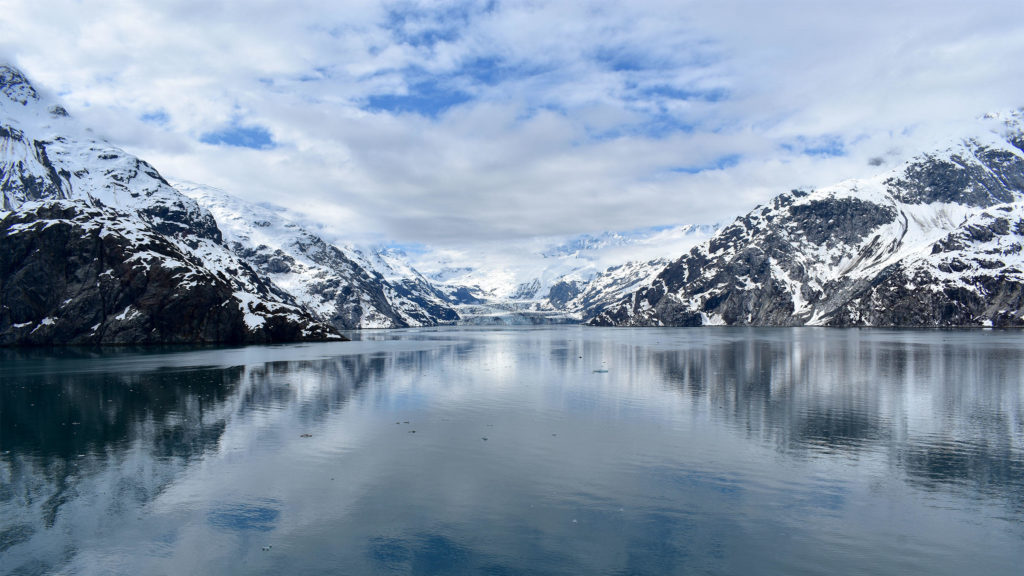
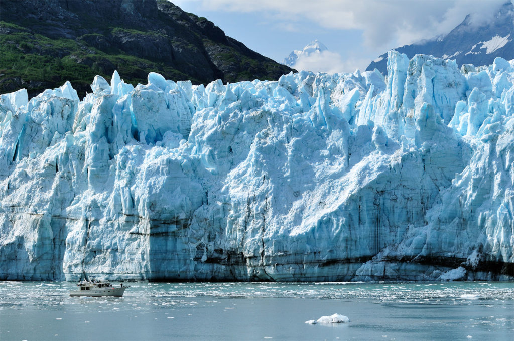
on February 25, 1925, President Calvin Coolidge proclaimed the area in Southeast Alaska, an area around Glacier Bay as the national monument. The park and preserve cover a total of 3,223,384 acres (5,037 sq mi; 13,045 km2), with 2,770,000 acres (4,328 sq mi; 11,210 km2) being designated as a wilderness area.
Wood Buffalo National Park of Canada
it is the largest National Park in Canadian Territory. At total area of 44,807 km2 (17,300 sq mi), It is in northeastern Alberta and the southern Northwest Territories, and that for better comparison make it larger than Switzerland. The park was founded in 1922 to protect the world’s largest herd of roaming free wood bison (currently reaching 5,000 in numbers). The park is also, one of only two known nesting sites of whooping cranes.
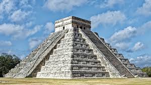
Pre-Hispanic City of Teotihuacan
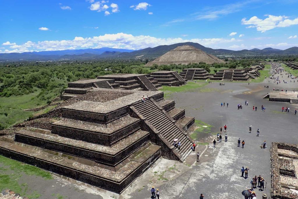
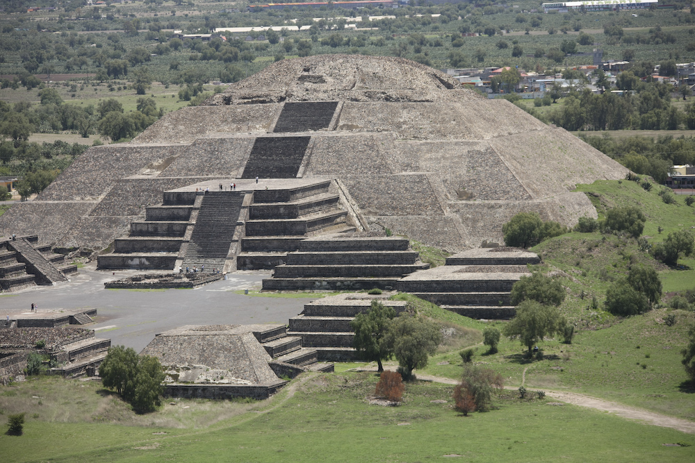
ancient Mesoamerican, which is in the State of Mexico, 25 miles (40 km) northeast of modern-day Mexico City. Teotihuacan is mainly known as a site of the most architecturally important Mesoamerican pyramids built in the pre-Columbian Americas. At its peak (1 CE to 500 CE), Teotihuacan was the largest city in the pre-Columbian Americas, with an approximate population of 125,000 or more, making it at least the sixth-largest city in the world during that’s time. The city covered eight square miles; Apart from the pyramids, Teotihuacan is also anthropologically significant for its complex, multi-family residential compounds, the Avenue of the Dead, and its vibrant, well-preserved murals. Furthermore, Teotihuacan was a main exporter of well-crafted obsidian tools that are found throughout whole Mesoamerica. The city may have lasted until sometime between the 7th and 8th centuries CE, but its major monuments were sacked and burned around 550 CE, and completely abandoned.
Monarch Butterfly Biosphere Reserve
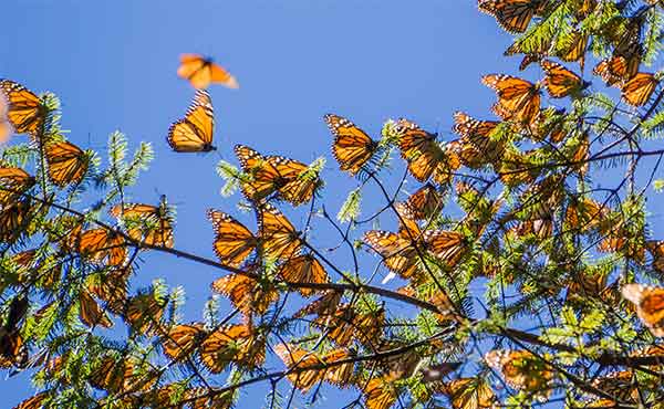
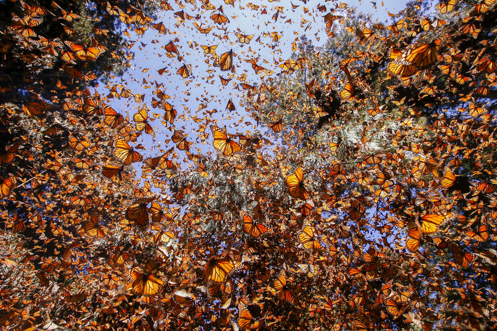
The reserve is located northwest of Mexico City. Millions of butterflies arrive in the reserve annually. Butterflies only inhabit a fraction of the 56,000 hectares of the reserve from October–March. The Reserve was declared a Biosphere Reserve in 1980 and a World Heritage Site in 2008. Millions of butterflies travel south into Mexico, from Texas and then follow the Sierra Madre Oriental mountains to the preserve. The butterflies gather, grouping onto pine and oyamel trees. To many, the trees appear orange and branches sag from the weight.
Pimachiowin Aki (“The Land That Gives Life”)
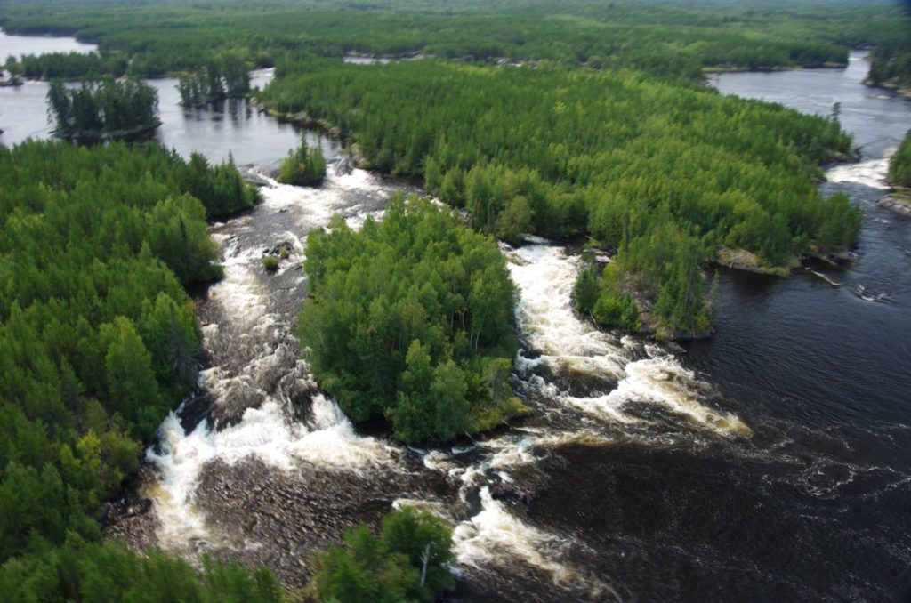
11,000 square miles (29,000 square kilometers) located in the parts of Manitoba and Ontario provinces, in Canada. The park includes ancestral lands of four First Nations (predominant indigenous peoples in Canada south of the Arctic Circle. Those in the Arctic area are distinct and known as Inuit.), including: Poplar River First Nation, Little Grand Rapids First Nation, Pauingassi First Nation, and Bloodvein First Nation. The park is a perfect example of respecting the land of the first people, their network of livelihood sites, habitation sites, travel routes and ceremonial sites, often linked by waterways, and keeping it in the unchanged state as a ling between the past and the future.
Old Havana and its Fortification System
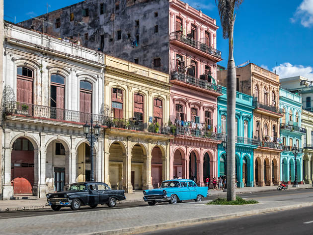
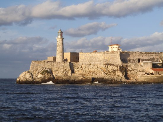
the city port of Havana, was established in 1519 by Spaniards, in the Havana Bay (modern day Cuba). The city quickly become busy port, between New World and Europe. By the 17th century, Havana was one on the biggest shipbuilding centers. Old Havana has preserved the remarkable harmony of old charm and character thank to its faithfulness to its original urban layout. Plazas surrounded by many buildings of outstanding architectural quality; narrow streets seep into the historic center of the city. The old city of Havana, enclosed inside city walls, kept with its five large plazas, each with its own architectural character: Plaza de Armas; Plaza Vieja; Plaza de San Francisco; Plaza del Cristo; and Plaza de la Catedral, with their own specific style of buildings.
Aqueduct of Padre Tembleque Hydraulic System
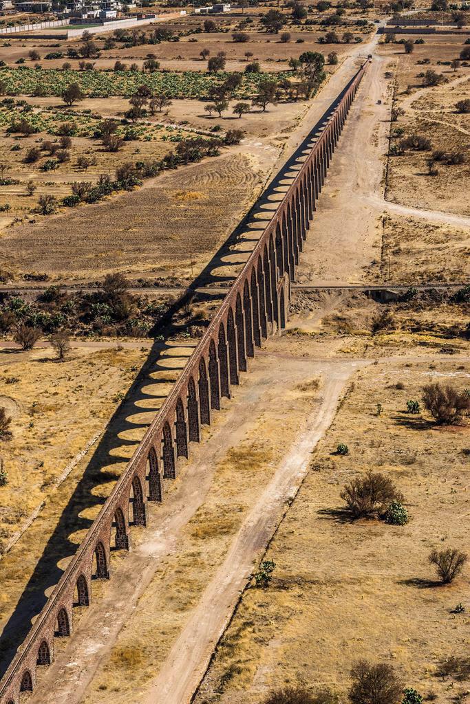
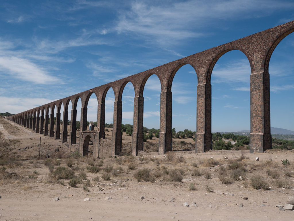
named after the friar Francisco de Tembleque. It was constructed between 1555 and 1572 to establishes a hydraulic system between the states of Mexico and Hidalgo in the Mexican Central Plateau. It stretches over 28 miles (45 kilometers) long. Its main construction is over the ground, but there are parts that runs underground as well as over canyons and valleys. There are three main waterways: the first has 46 arches, the second has 13, and the third has 67 arches. In Papalote Valley, which is connected by the 67-arch arcade (known as the Main Arcade), has the tallest arch standing 127.1 ft (38.75 meters) tall.
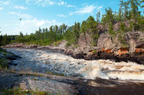
Nahanni National Park
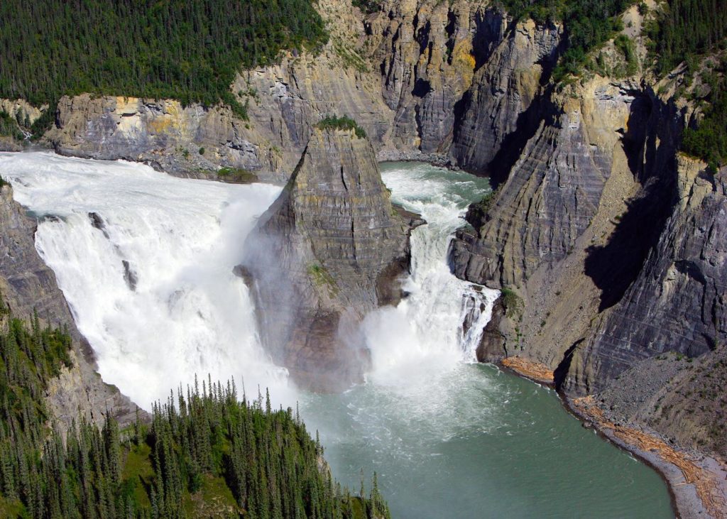
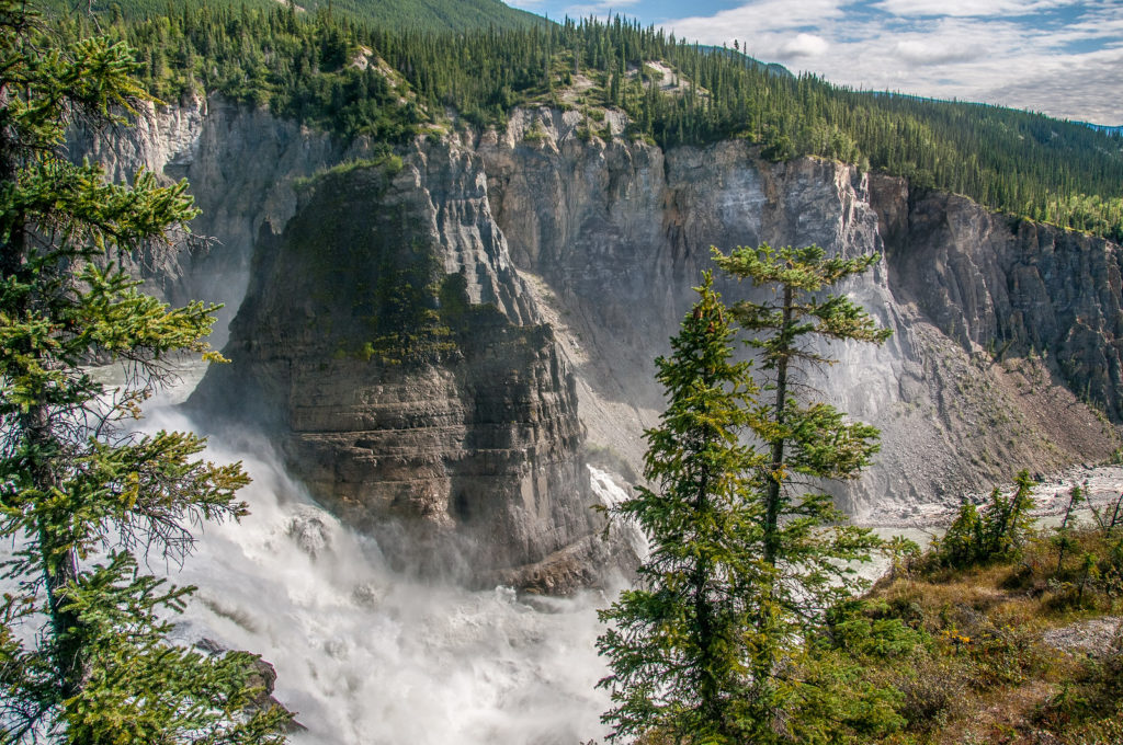
situated inthe Mackenzie Mountains Natural Region, in Northwest Territory of Canada. 470,000-hectare undisturbed natural area of deep river canyons cutting through mountain ranges, with huge waterfalls and complex cave systems. The South Nahanni River (Naha Dehé), that is runs through the whole territory, gave the part its name. The main attraction, or the centerpiece you may say, are for stunning Canyons, named simply: First (considered the most beautiful of all of them, runs for about 19 mils (30 kilometers); Second (runs for about 9.3 miles (15 km); Third (runs for about 25 miles (40 kilometers) long; and Fourth (also called Painted Canyon or Five Mile Canyon due to its length of 5 miles).
Redwood National and State Parks
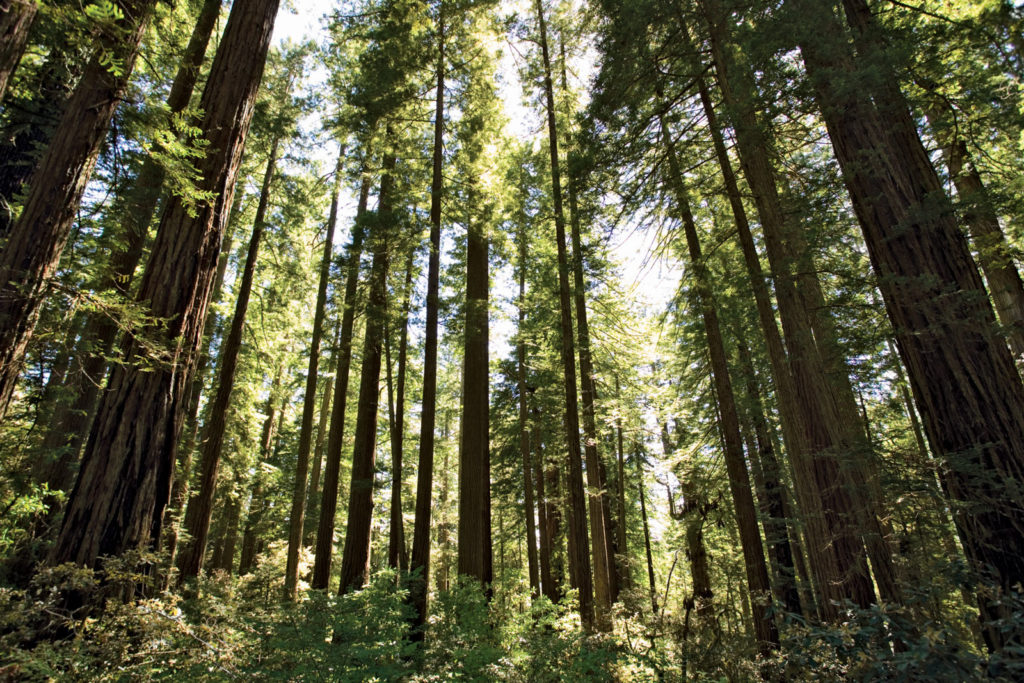
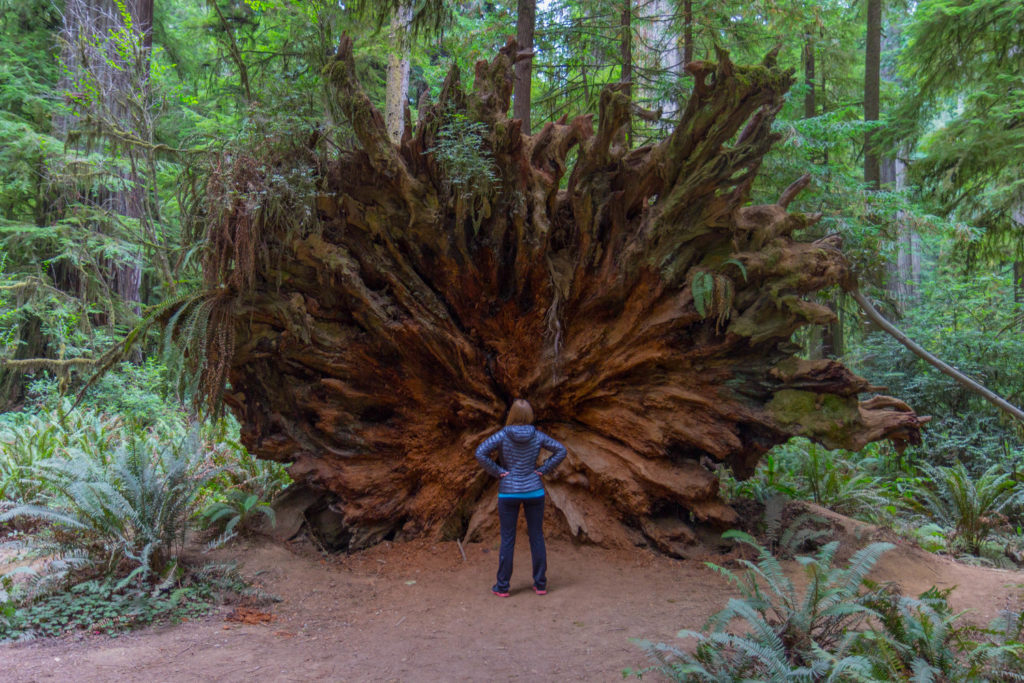
is a combination of few parks (state and national) located alongside coast of northern California. The whole complex was established President Lyndon Johnson on October 2, 1968. Redwood National Park, California’s Del Norte Coast, Jedediah Smith, and Prairie Creek Redwoods State Parks, combined cover 139,000 acres (560 km2). The four parks, together, protect 45% of all remaining coast redwood (Sequoia sempervirens) old-growth forests. These trees are the tallest, among the oldest, and one of the most massive tree species on Earth. In addition to the redwood forests, the parks preserve other indigenous flora, fauna, grassland prairie, cultural resources, portions of rivers and other streams, and 37 miles (60 km) of pristine coastline.
Pre-Hispanic City and National Park of Palenque
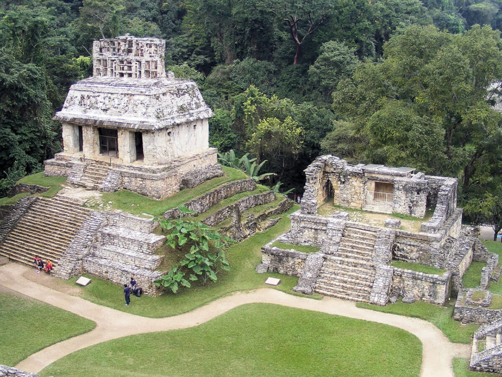
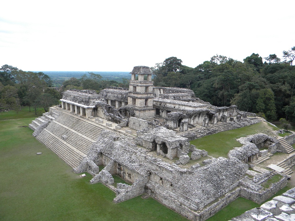
Ancient Maya city state in modern Southern Mexico. known as Lakamha (that is translates to “Big Water”), flourished in the 7th century. Palenque, even though not the largest of Mayan cities, contains some of the finest architecture, sculpture, roof comb and bas-relief carvings that the Mayas produced. Much of the history of Palenque has been reconstructed from reading the hieroglyphic inscriptions on the many monuments. After its decline, it was overgrown by the jungle of cedar, mahogany, and sapodilla trees,
Statue of Liberty (Liberty Enlightening the World)
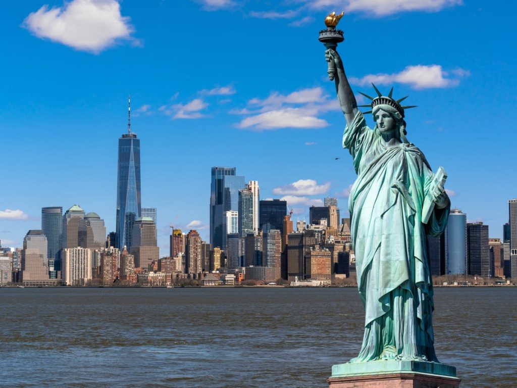
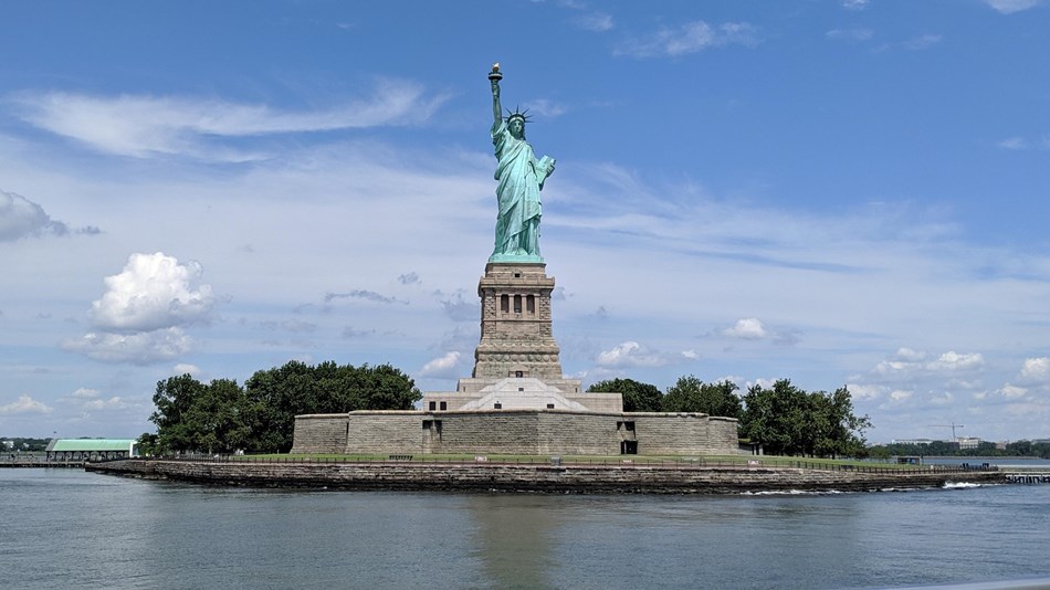
the gift from the people of France to the people of the United States, dedicated on October 28, 1886. It was designed by Frédéric Auguste Bartholdi and its metal framework was built by Gustave Eiffel (yes, the same who designed and build thee Eiffel Tower in Paris). The copper statue stands on Liberty Island in New York Harbor within New York City territory. She holds a torch above her head with her right hand, and in her left hand carries a tablet inscribed JULY IV MDCCLXXVI (July 4, 1776, in Latin numbers), the date of the U.S. Declaration of Independence. A broken shackle and chain lie at her feet as she walks forward, commemorating the recent national abolition of slavery. The colossal statue measures (to torch): 151 feet 1 inch (46 meters); From ground level to torch: 305 feet 1 inch (93 meters).
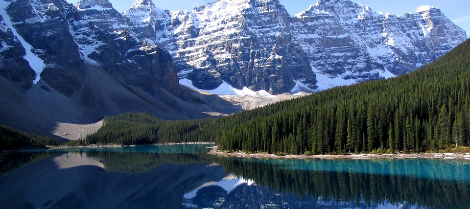
Canadian Rocky Mountain Parks
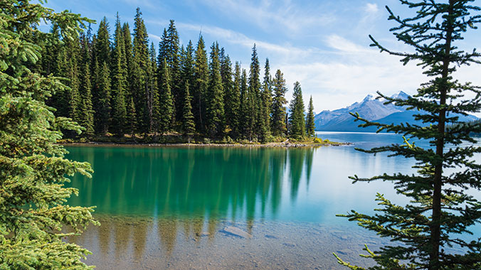
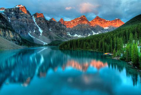
complex of connected parks Canadian Rocky Mountains. Four of them being national parks: Banff; Jasper; Kootenay; Yoho; and three are established British Columbia provincial parks: Hamber Provincial Park; Mount Assiniboine Provincial Park; Mount Robson Provincial Park. The parks include multiple mountains (such as Mount Robson (3,954 m, 12,972 ft) and Mount Columbia (3,747 m, 12,293 ft)), glaciers, hot springs and the of major North American rivers running through them: North Saskatchewan River; Athabasca River; Columbia River; Fraser River.
Mesa Verde National Park
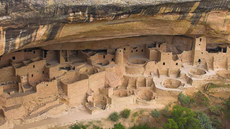
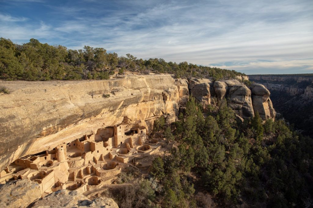
located in Colorado. Established by Congress and President Theodore Roosevelt in 1906, the park covers 52,485 acres (21,240 ha) near the Four Corners region (the southwestern corner of Colorado, southeastern corner of Utah, northeastern corner of Arizona, and northwestern corner of New Mexico.) of the American Southwest. The park protects some of the best-preserved Ancestral Puebloan archaeological sites in the United States. With more than 5,000 sites, including 600 cliff residences, it is the largest archaeological preserve in the United States. Starting c. 7500 BC Mesa Verde was seasonally inhabited by a group of nomadic Paleo-Indians known as the Foothills Mountain Complex. The Mesa Verdeans survived using a combination of hunting, gathering, and subsistence farming of crops such as corn, beans, and squash. They built the mesa’s first pueblos sometime after 650, and by the end of the 12th century, they began to construct the massive cliff dwellings for which the park is best known.


Wow its such lovely sceeneries, makes you dream while were stuck in nationwide lockdown! Definately will be creating a bucket list shortly!
I am so happy to hear that. some of the places are stunning. and i was thinking about making a post of my bucket list.. posting Heritahe Sites from South America now, and the other continents are coming…
Czytając o Parku Narodowym Yellowstone pomyślałam o misiu Yogy❤️🐻❤️
Jakie piękne i zróżnicowane krajobrazy
🌄🌇🏞️🏜️🗻🌋⛰️🛤️🏝️⛱️🏔️🌉🌌🛣️🌆🌃
Yellowstone już jest na mojej liście TO DO 🌋
Tylko pakować walizki…🧳💺✈️🛬🛫🛳️
Tylko pakować walizki…🧳💺✈️🛬🛫🛳️