Second stop. South American Continent
Central Amazon Conservation Complex
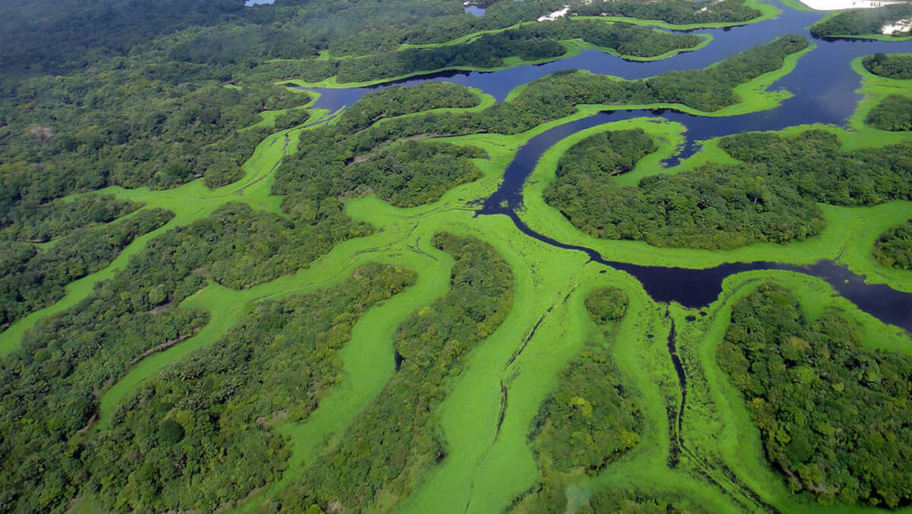
this is the largest protected area in the Amazon basin. It covers an area of 2,367,333 hectares (5,849,810 acres). It was created on 24 September 1980. The territory is significant for its high biodiversity, range of habitats ( várzea and igapó forests) and number of endangered species. It has been recognized by various conservation agencies as a high priority region
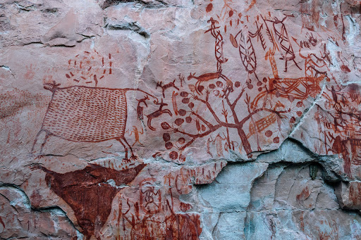
Cueva de las Manos, Río Pinturas (Cave of Hands)
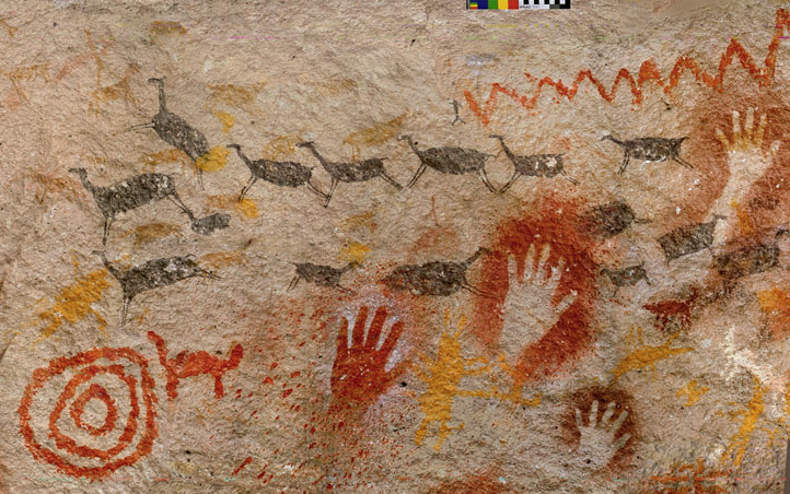
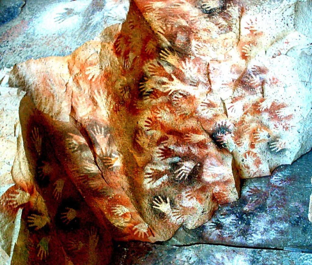
is a sequence of caves located in Santa Cruz province, in Argentina. Its name, and the fame comes from the paintings of hands inside the cave systems. The art in the cave dates from 13,000 to 9,000 years ago; early artwork has been carbon-dated to ca. 9300 BP (about 7300 BC). Several waves of people occupied the cave, and they are believed to be the creative ones, who were using hollow bones for spraying the paint on the wall of the cave to create silhouettes of hands.
Galápagos Islands
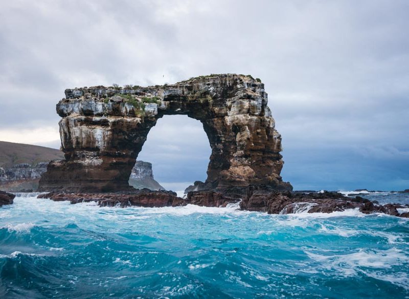
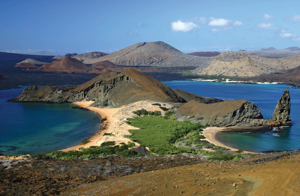
are an archipelago of 21 volcanic islands scattered on either side of the equator in the Pacific Ocean. Located 563 miles (906 kilometers) west of Ecuador and covering in total area of 3040 square miles (7880 square kilometers). The islands are best known for their large number of common species that were studied by Charles Darwin. His observations and collections contributed to the inception of Darwin’s theory of evolution by means of natural selection.
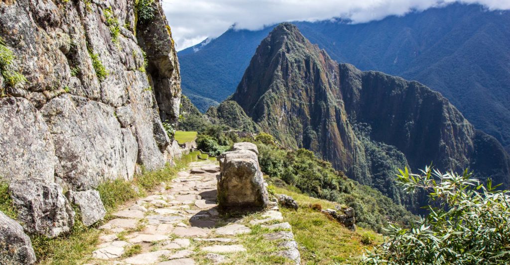
Historic Sanctuary of Machu Picchu
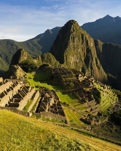
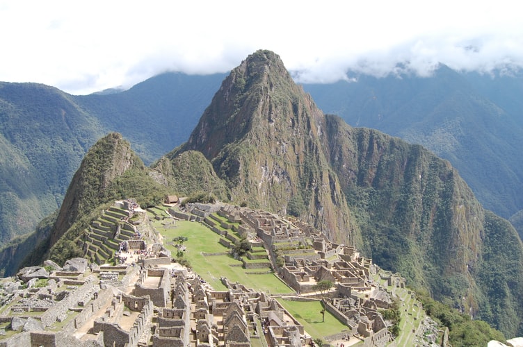
is a 15th-century Inca citadel (the core fortified area of a town or city. It may be a castle, fortress, or fortified center. The term is a diminutive of “city” and thus means “little city” so called because it is a smaller part of the city of which it is the defensive core), located in the Eastern Cordillera of southern Peru, on a 2,430-metre (7,970 ft) mountain ridge. Archaeologists believe that Machu Picchu was constructed as an estate for the Inca emperor Pachacuti (1438–1472). Repeatedly mistakenly referred to as the “Lost City of the Incas” (most familiar icon of Inca civilization). The Incas built the estate around 1450 but it was abandoned only one century later (just before the Spanish conquest). It was built in the classical Inca style, with polished dry-stone walls. Its three most important structures are the Intihuatana (notable ritual stone associated with the astronomic clock or calendar of the Inca), the Temple of the Sun, and the Room of the Three Windows.
Huascarán National Park
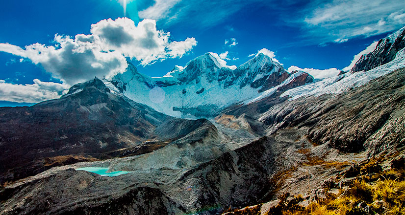
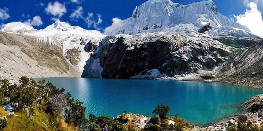
Peruvian national park that covers most of the mountain range known as Cordillera Blanca (the world’s highest tropical mountain range). The park situated in central Peruvian Andes, covers an area of 340,000 ha (ca. 3.400 km2), and is approximately 93 miles (150 kilometers) long from north to south and averages about 16 miles (25 kilometers) in width. The heights span from around 1.55 mile (2,500 meters) to above 3,37 miles (6,000 meters), with a few snowy peaks reaching that height. Among them are Huascarán (Peru’s highest at 4.2 miles – 6,768 meters), Huandoy (3.97 miles – 6395 meters), Copa (3.84 miles – 6188 meters), Huantsán (3.95 miles – 6369 meters) but there are many others. Other geographical highlights that the park has to offer, are: U-shaped valleys, 660 tropical glaciers (the largest glaciated area in the tropics), 300 glacial lakes and high plateaus intersected by ravines with torrential creeks.
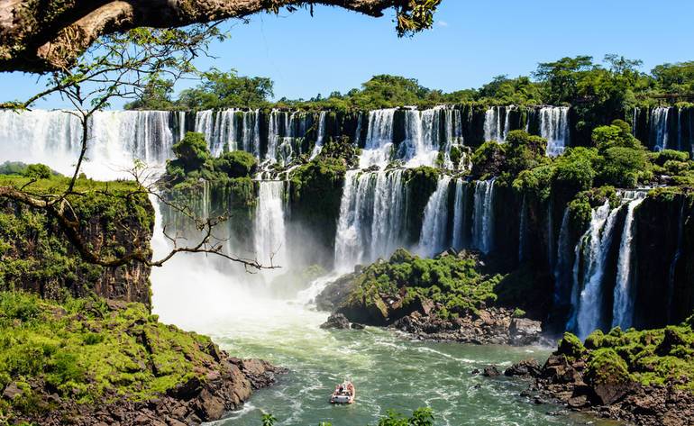
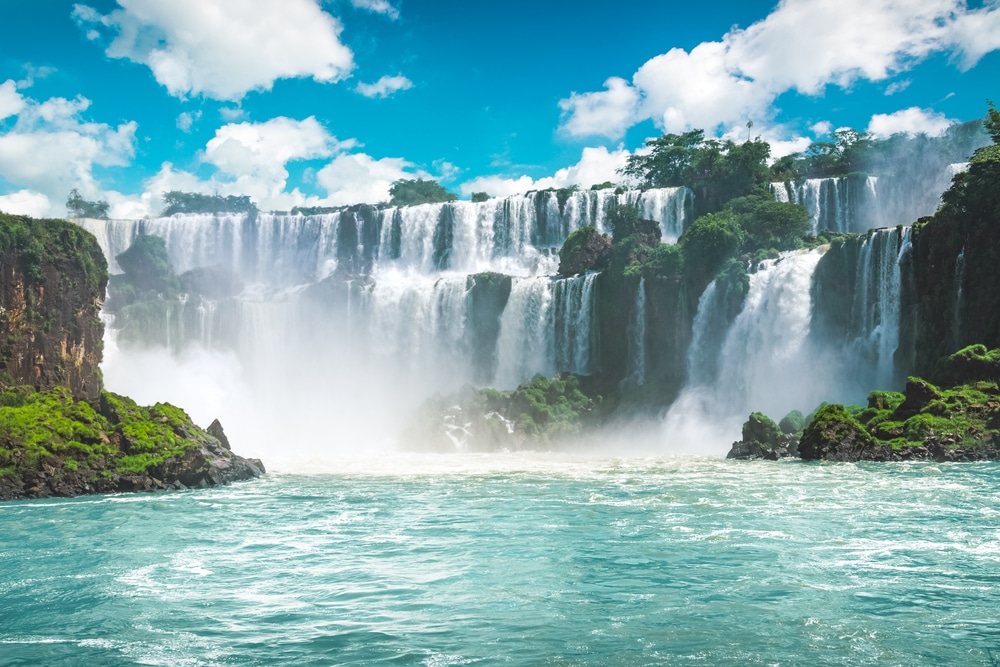
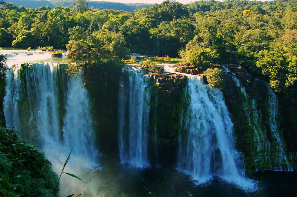
Iguaçu National Park
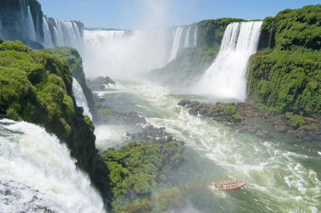
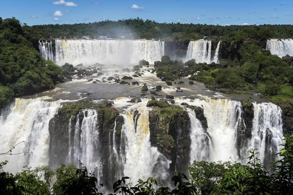
created by federal decree nr. 1035 of January 10, 1939, one of the most stunning places in Brazil, located in Parana State. The park stretches over the area of 185,262.5 hectares (457,794 acres) and a length of about 260 miles (420 kilometers), 190 miles (300 kilometers). It also has natural water borders with Argentine, stretching a little bit to the neighbor side. Both sides together consist of around 260,000 hectares (640,000 acres). Brazil and Argentina share one of the world’s largest waterfalls, extending over some 8.900 feet (2,700 meters). The Park is a home to many rare and endangered species of flora and fauna. Giant otter and the giant anteater are only two examples of many.
Noel Kempff Mercado National Park
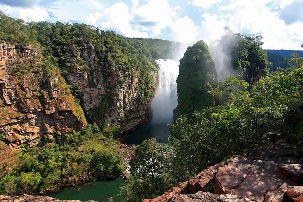
750,000 hectares of land in Bolivia, are enclosing stunning vies inside that nature park. The park is made up of five distinct habitats, including upland evergreen forest, deciduous forest, upland cerrado savanna, savanna wetlands, and forest wetlands. It is confirmed by the scientist, that there are thousands of plants (2700 already identified, over 6000 still waiting in line for their name), and of course there are animals. more than 130 species of mammals (rare river otters, river dolphins, tapirs, spider and howler monkeys, the giant armadillo, giant anteaters, and endangered jaguars, including a population of black jaguars), 620 species of birds (nine species of macaw, possibly the highest number of species in any one protected area), and more than 70 species of reptiles, including the black caiman. No offence to flora as fauna, but the star of the park are the waterfalls! The Huanchaca Plateau (also known as Caparu Meseta) rise to 300 meters (985 ft) tall; Arcoiris Falls (88 meters (290 ft)); Frederico Ahlfeld Falls (25–45 meters (80–150 ft)), and El Encanto Falls (80 meters (260 ft)).
Ischigualasto / Talampaya Natural Parks
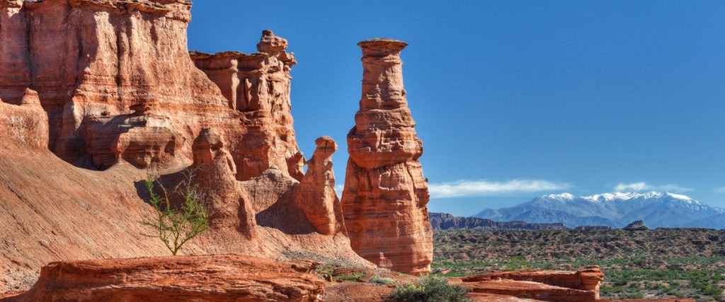
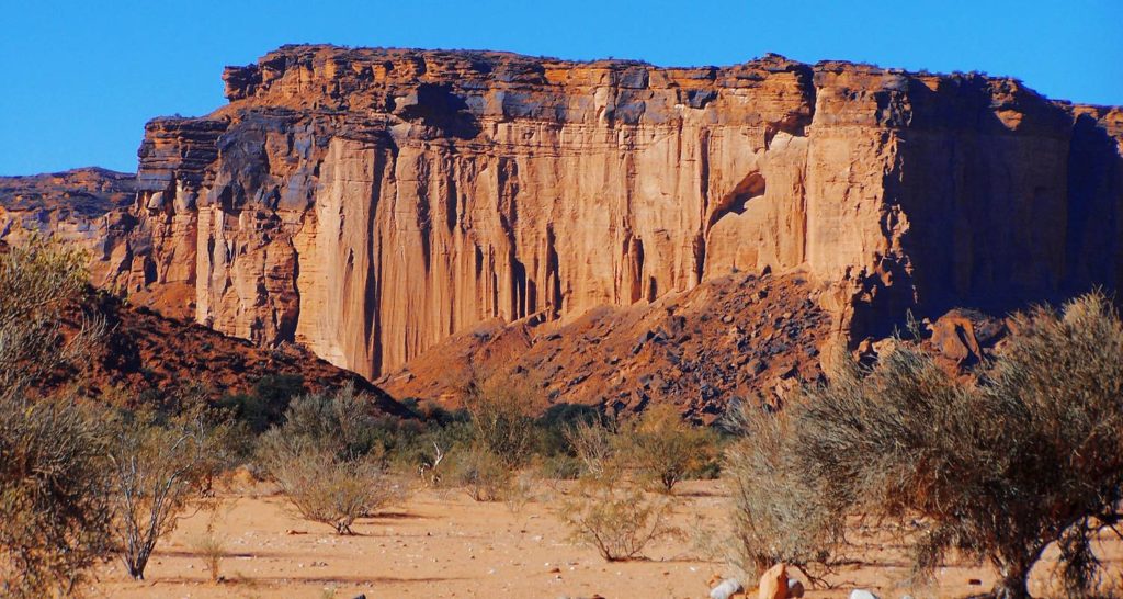
Those two combined parks in Argentina stretching over 275,300 ha in the desert at an altitude up to 4,921 feet (1,500 meters) above sea level. Its main purpose is to protect important archaeological and paleontological sites found in the area, that contain the most complete mainland fossil known from the Triassic Period (245-208 million years ago). All the six geological formations in the parks, contain fossils of ancestors of mammals, dinosaurs, and plants (revealing the evolution of vertebrates in animals). Ischigualasto since 1943 is called by the locals and scientist Valle de la Luna (“Valley of the Moon” or “Moon Valley”), due to its moon like appearance. The region received for the first time the name Valle de la Luna in 1943, It has landscapes of great beauty, with flora and fauna typical of the mountain biome.
Lines and Geoglyphs of Nazca and Pampas de Jumana
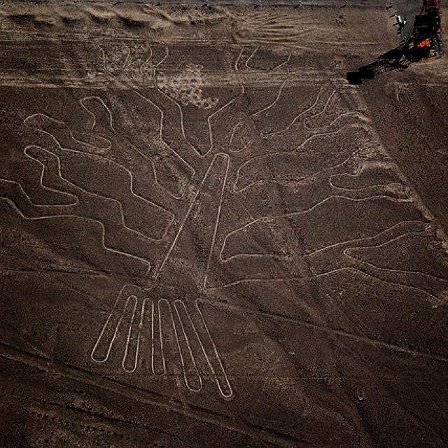
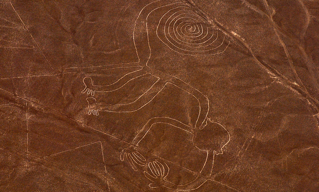
Complex of exceptionally large geoglyphs made in the Nazca Desert in southern Peru. It is believed that they were created between 500 BCE and 500 CE by Nazca indigenous people. They were able to achieve this by removing the top of the dessert soil, removing pebbles, and leaving differently colored dirt exposed; top layer of reddish-brown iron oxide-coated pebbles to reveal a yellow-grey subsoil. The cuts in the soil are typically 4 to 6 inches (10 to 15 cm) deep. The design shows plenty of straight lines, running across the Nazca Plateau, but there are also elaborate designs of animals and plants (more than 70 designs including: a hummingbird, spider, fish, condor, heron, monkey, lizard, dog, cat, a human, trees, and flowers). The individual glyphs figures measure between 0.2 to 0.7 mile (0.4 and 1.1 km) across. The whole combined surface covers an area of about 19 square mile (50 square kilometer), and runover 800 miles (1,300 km) in length.
Malpelo Fauna and Flora Sanctuary
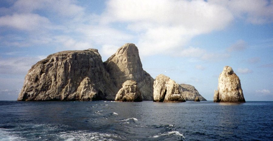
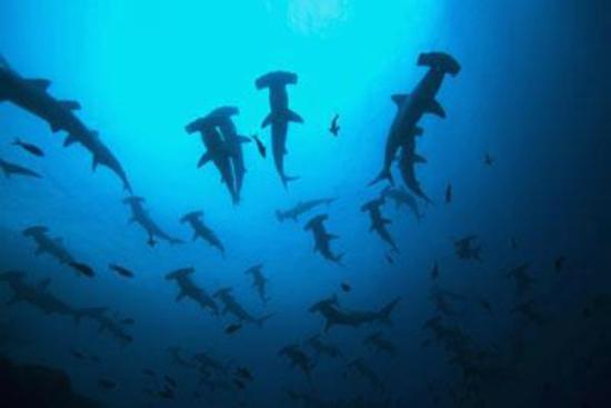
wildlife sanctuary is enclosed in the radius of 6000 miles (9.656 kilometers), with visible one, small island about 310 miles (500 kilometers), on eastern Pacific Ocean west of Colombia. The island is about 1mile (1.5 kilometers) in length, and700 yards (640 meters) in width. The main feature is a lonely rock with three high peaks (the highest one – Cerro de la Mona (980 feet – 300 meters)). Malpelo Ridge (solitary volcanic submarine ridge) that stretches on the length of 190 miles (300 kilometers) and a width of 62 miles (100 kilometers). To reach the bottom of the rock formation, you must go between 1.1 mile to 5.65 moles (1,800 and 9,100 meters) down deep.
At first the island seems to be steep, barren rock, without any life. But, surprise, surprise Malpelo is home of a unique shark population; 500 or more Hammerhead sharks and hundreds of Silky sharks. It is one of unique few places where the Smalltooth sand tiger (Mackerel Shark) has been seen alive. They can be observed by diving expeditions, making it an extremely popular diving location, for shark’s enthusiasts.
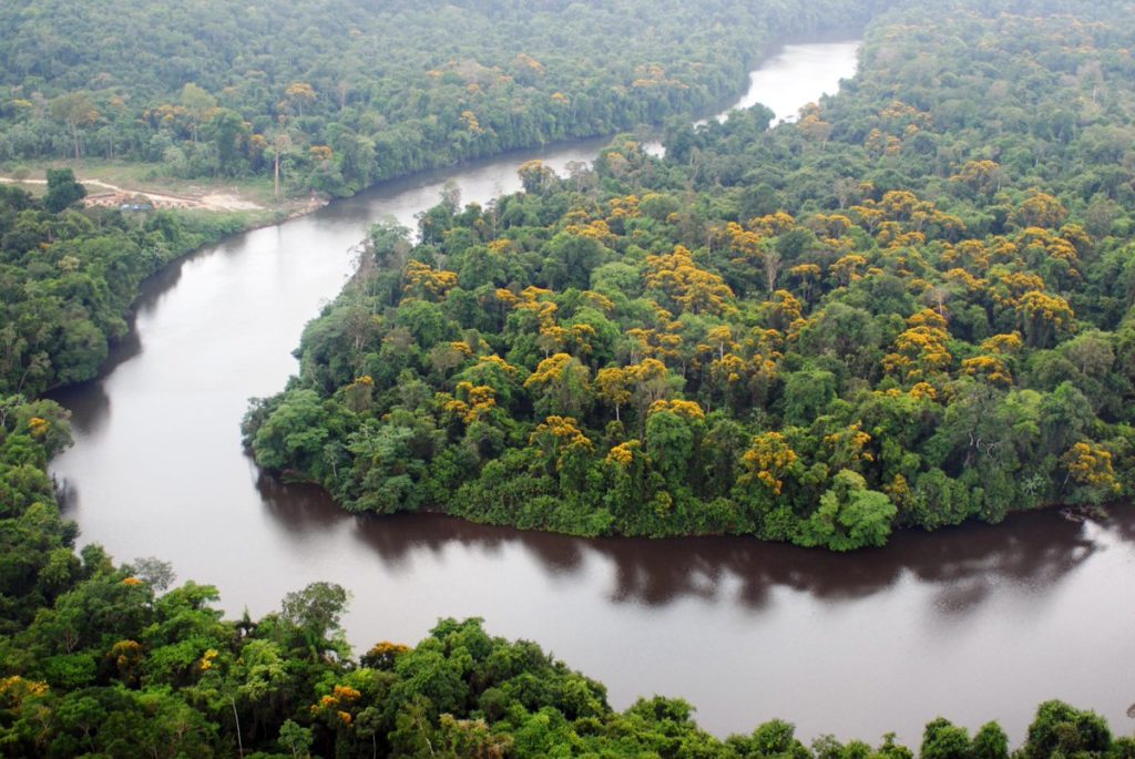
Pantanal Conservation Area
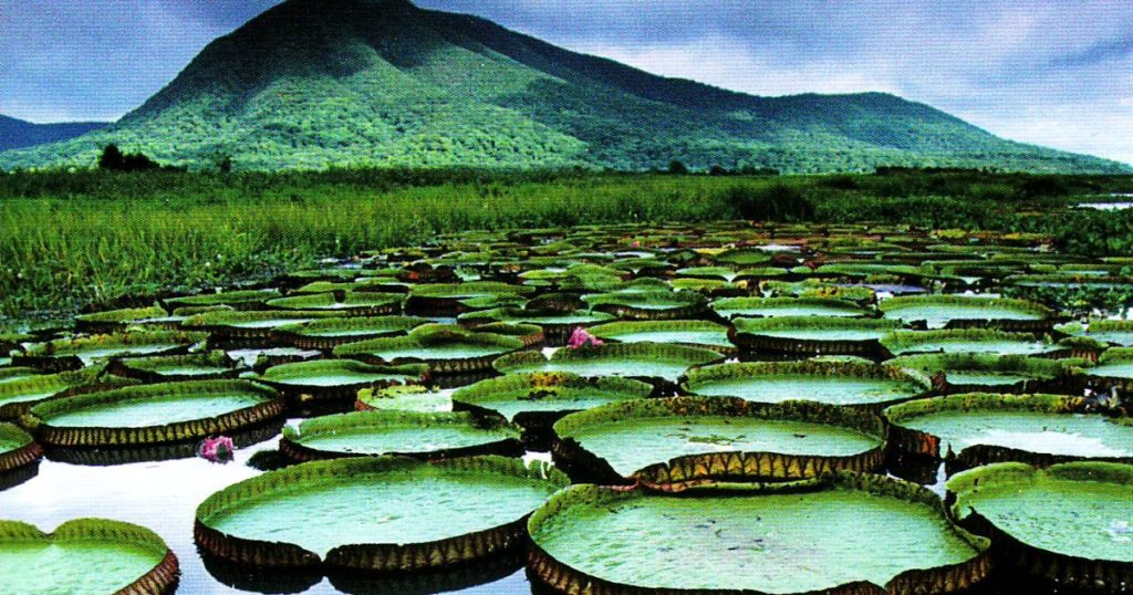
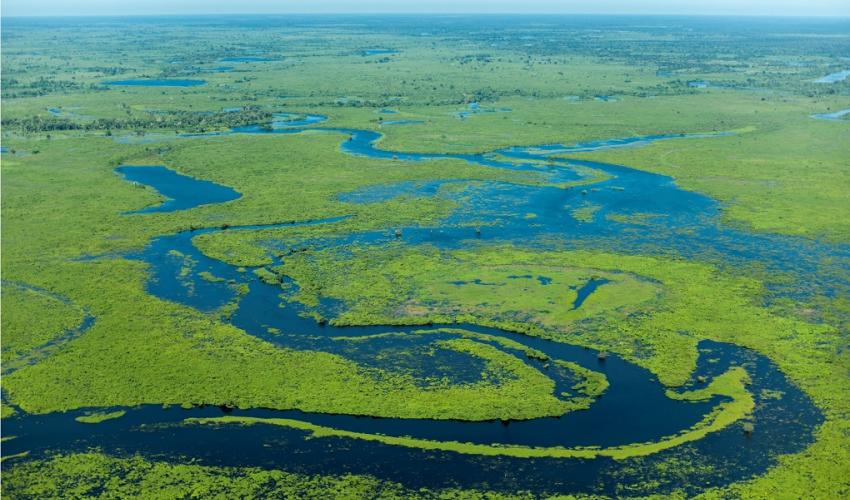
world’s largest tropical wetland area, and in the same time world’s largest flooded grasslands. Located in the main part in Brazil, but it stretches into parts of Bolivia and Paraguay. Vast area in the size between 54,000 and 75,000 sq miles (140,000 and 195,000 square kilometers). The green life of the Pantanal, often referred to as the “Pantanal complex”, is a mixture of tropical Amazonian rainforest plants, semiarid woodland plants, plants od forest and savannah. The Pantanal is also home to 463 bird species, 269 fish species, more than 236 mammalian species,141 reptile and amphibian species, and over 9,000 subspecies of invertebrates. Among the rarest animals to inhabit the wetland of the Pantanal are: apple snail; the marsh deer; the giant river otter; the hyacinth macaw; the crowned solitary eagle; the maned wolf; the bush dog; the South American tapir; the giant anteater. Among the common ones you can identify: capybara; Ocelot; yacare caiman (there are more than 10 million of them).
Península Valdés
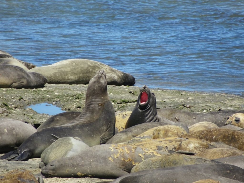
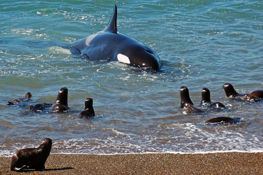
It is a nature reserve on the coast of Argentina. Around 896,000 acres; 1,400 square miles (3,625 square kilometers) in size. It is known for the marine animals inhabiting its surrounding beaches and waters. Coast features rocky cliffs, shallow bays and lagoons, sandy and pebble beaches, active sand dunes, and small islands. The wetlands provide significant nesting and resting sites for numerous migratory shorebirds. It is home to an essential breeding population of the endangered southern right whale as well as crucial breeding populations of southern elephant seals and southern sea lions. The greatest of all sea predators, The Orca whale, developed fascinating hunting technique, to feed on the sea mammals. There are 181 recorded bird species, well known: Lesser Rhea, the White-headed Steamer Duck, endemic to Argentina, and the migratory Snowy Sheathbill. The fact is, that with more than 1,500 varieties of animals visiting the area annually Peninsula Valdes is an extraordinary place, worth protecting for the future generations.
Easter Island heads, Easter Island (Rapa Nui)
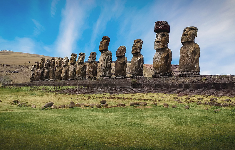
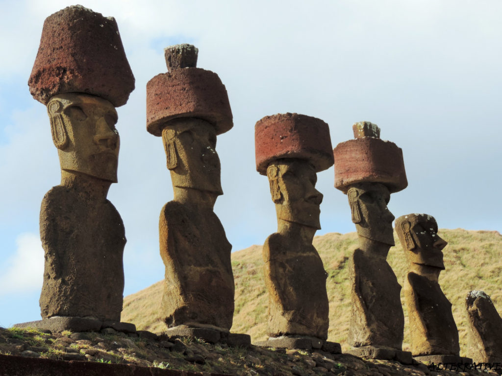
island at the southeastern Pacific Ocean and, belonging to territory of Chile. Located at the Polynesian Triangle in Oceania (southeasternmost point). most famous for its nearly 1,000 extant monumental statues, called moai, created by the early Rapa Nui people. Archaeologists believe that they arrived on the island around 800 CE, though there are a second popular hypotheses, placing their arrival to be 1200 CE. The first (on the official record) European contact with the island was on 5 April 1722. Exactly on Easter Sunday, by Jacob Roggeveen (Dutch navigator), and that give the island its name. The island is most famous, and most recognizable for its monumental statues, called “Moai”, created by the early Rapa Nui people. 887 human figures, rock carved, somewhere between 1250 and 1500 CE are situated throughout Easter Island. The moai statues were believed to be the living faces of ancestors and had all been toppled by 1868. The moai rest on large stone platforms called “ahu”, the most famous of which are Ahu Tongariki, the largest ahu, and Ahu Vinapu. Some moai have hats of red volcanic stone known as “Pukao”.
Tiahuanacu (Tiwanaku, Tiahuanaco or Tiahuanacu) is Spiritual and Political Centre of the Tiahuanacu Culture
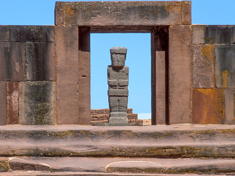
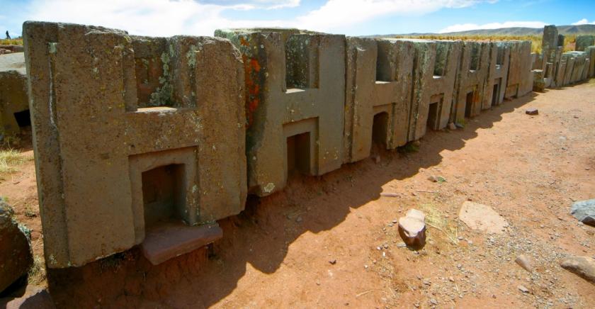
site in western Bolivia near Lake Titicaca (from Pre-Colombian era); one of the largest archaeological sites in South America. Its population probably peaked about 800 AD, with up to 20,000 people living there. Remains in the surface, stretches around 4 square kilometers. It is extremely important in Inca traditions, because they believed to be the site where the world was created. The whole site includes decorated ceramics, monumental structures, and megalithic blocks. The structures include: the Akapana, Akapana East, and Pumapunku (probably the most known) stepped platforms, the Kalasasaya, the Kheri Kala, Putin enclosures, and Semi-Subterranean Temple.
Rio de Janeiro: Carioca Landscapes Between the Mountain and the Sea
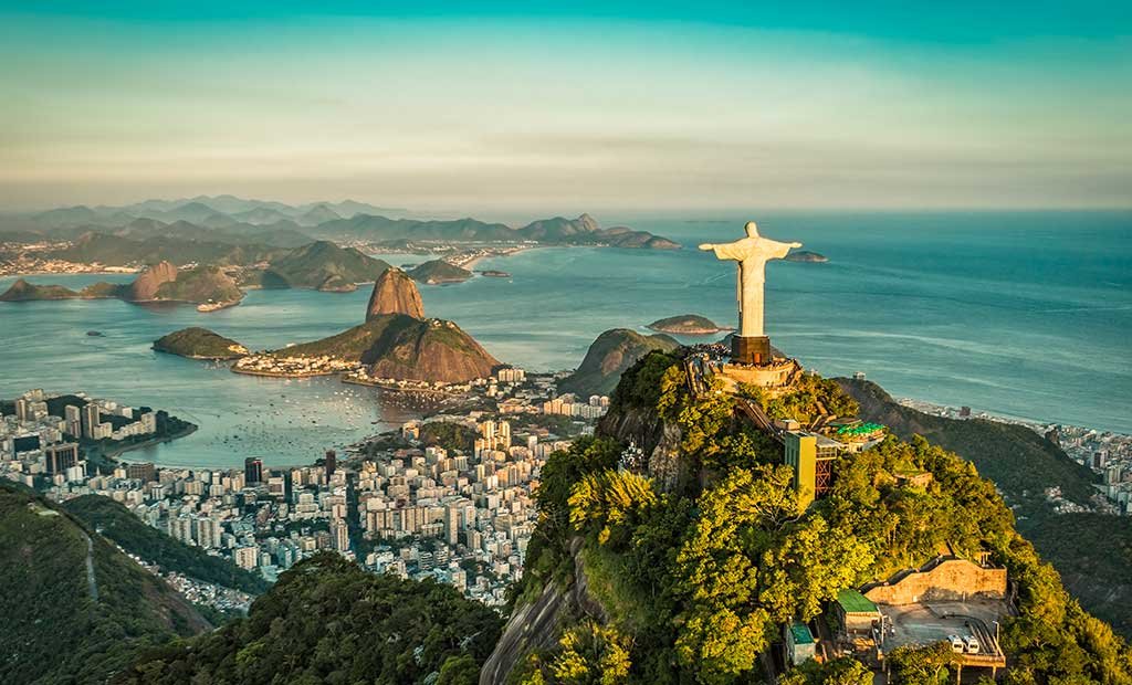
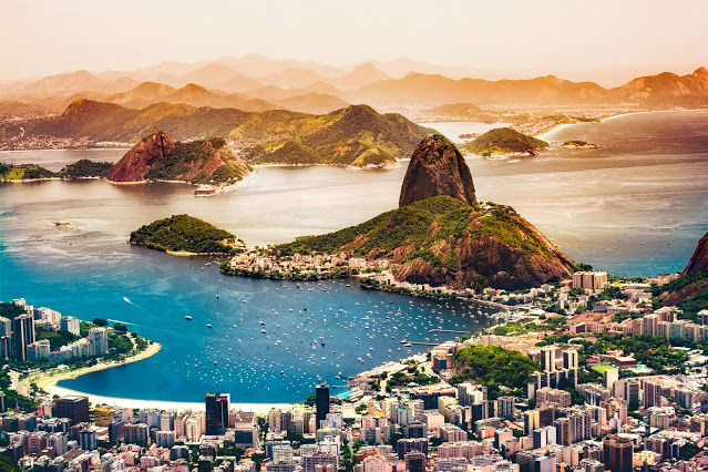
Rio’s natural landscape coming together with meticulous urban planning. From 17th century modified to allow sugar and coffee growing. From the highest points of the Tijuca National Park’s mountains down to the sea, to the sandy beach, so much contributed to the outdoor living culture of this city. The designated area includes following parts: Tijuca National Park, including Corcovado peak and its Christ the Redeemer statue
Botanic Garden; Flamengo Park; The mouth of the Guanabara Bay; Sugar Loaf; Copacabana Beach Front. Rio de Janeiro is credited for flourishing artistic culture, to musicians, city architects and garden planners.
National Archeological Park of Tierradentro
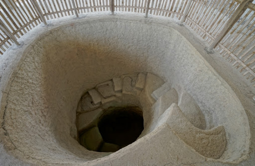
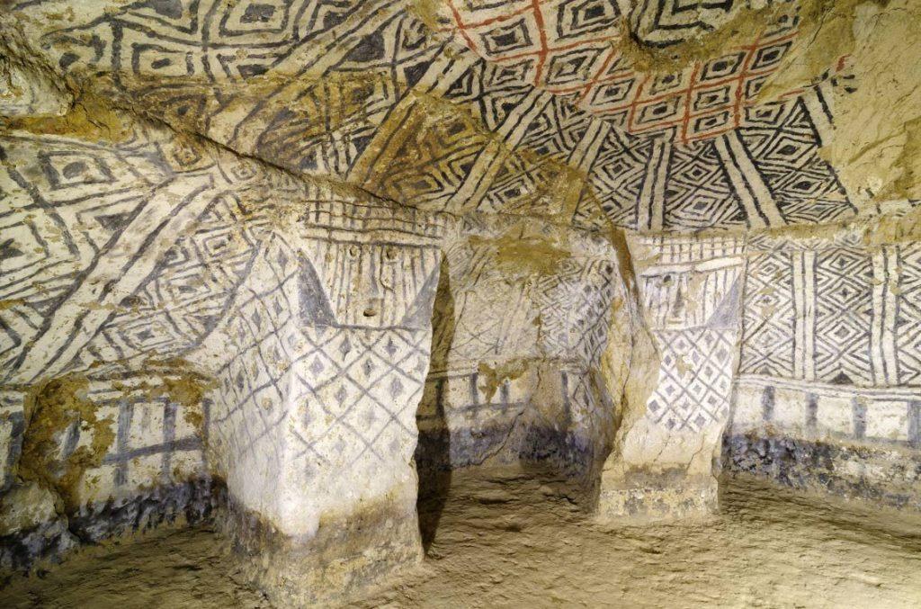
this site was once a home the ancient, Pre-Columbian culture of Colombia. That thrived between 200 BC to the 17th century. The area is very well known for its hypogea (literally translate to ” underground”) constructions. They give us an amazing look into funerary rites and traditions. The classically looking hypogeum has an entry (always oriented to the west), spiral staircase and a main chamber, usually 5 to 8 meters below the surface, with several lesser chambers located around (each one with a buried body). The walls are painted red, black, and white, with geometric, humanlike, and animal patterns.
Qhapaq Ñan, Andean Road System
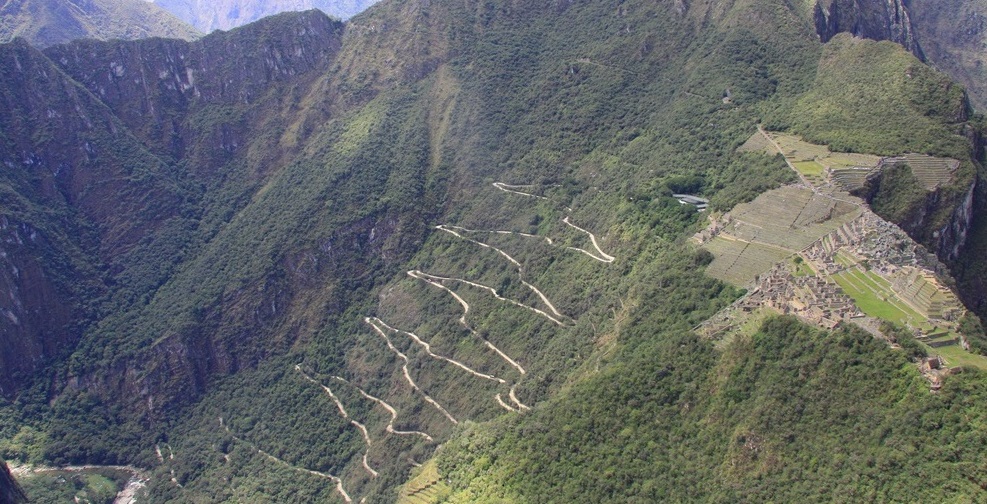
widespread and advanced transportation system in pre-Columbian Peru. The network was composed of official roads carefully planned, engineered, built, marked, and maintained; paved where necessary, with stairways when the elevation was increasing, bridges and additional constructions such as retaining walls, and water drainage system. The Incas gave priority to the straightness of the roads, whenever possible, to shorten the distance. It was based on two north-south roads: one along the coast and the second and most important inland and up the mountains, both with various crossroads. It was at least 25.000 miles (40,000 kilometers) long. The Incas used the road system for a wide range of purposes: transportation for people throughout the Inca Empire, trade and craftsmanship, military, and religious purposes. The road system allowed for a fast movement, from one part of the Empire to the other; It also allowed for the fast passage of information and valuable small goods and even transport of animals (Lamas and Alpacas).
Serra da Capivara National Park
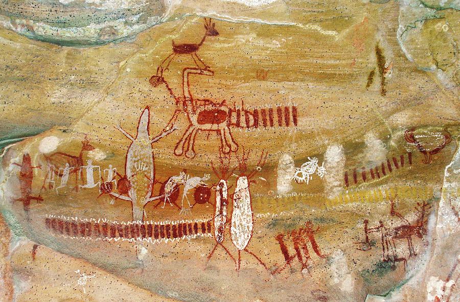
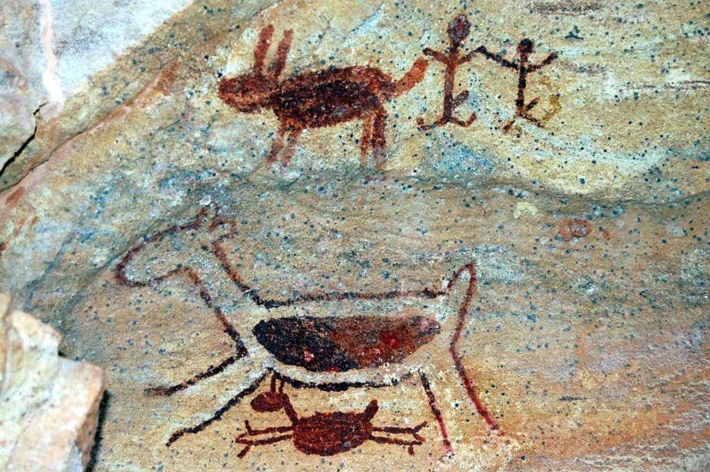
area of 319,000 acres (1291.4 square kilometers), in North Eastern part of Brazil, is one of the most archaeologically significant location. In the enclosure of the park, over 300 archaeological sites have been found: the majority containing rock and wall paintings dating from 50,000-30,000 years Before Present. It is an undeniable proof of highly populated settlement, thousands years ago, in Southern America. The park represents and preserves the oldest examples of rock art in the Americas. Furthermore, the iconography of the paintings allows us to discover information about the region’s early people.
Historic Centre of Lima
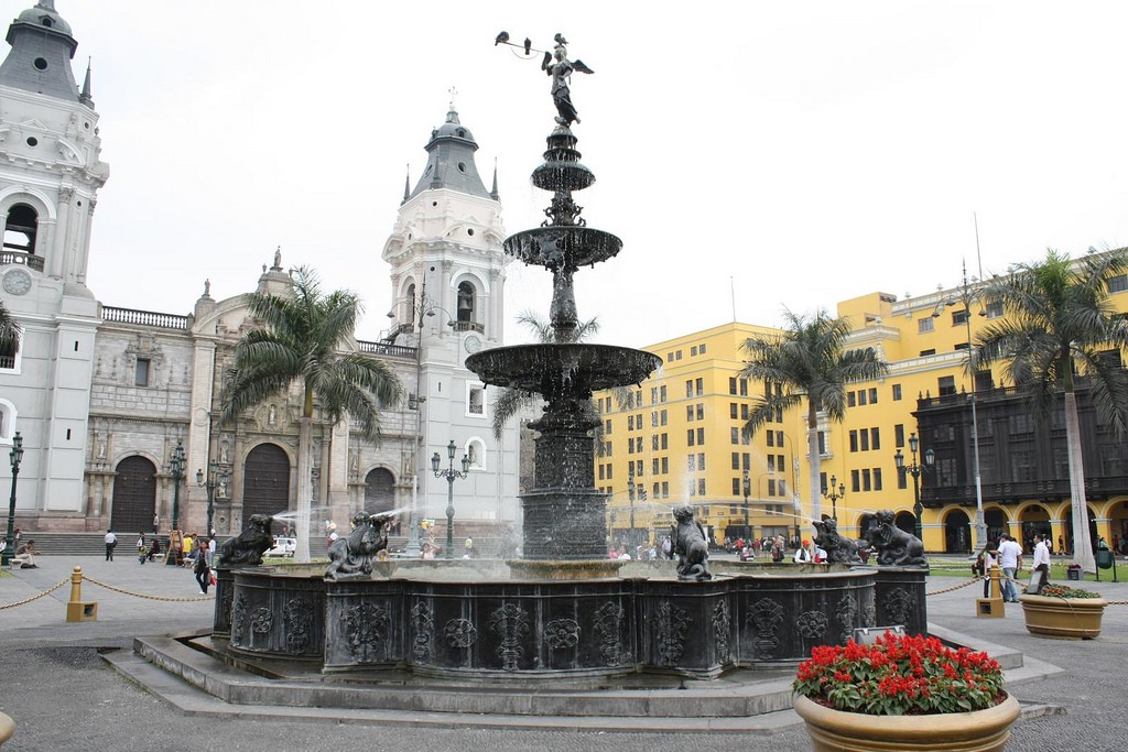
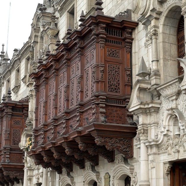
Lima (capital of modern Peru) was founded by Francisco Pizarro on 18 January 1535 and given the name “City of the Kings”. In 1988 Lima became a World Heritage Site for its originality and high concentration of historic monuments constructed in the time of Spanish presence. Of the main structure in the historical center of Lima, are more than 1,600 balconies that were built in the times of Spaniards, to adorn newly founded city. The astonishing work of art was created, a magnificence, a grandeur, and almost legendary spending, to show off to the rest of the Old World. Nowadays the historic Centre of Lima, is one of the most popular tourist attractions, and the best places to visit will be: Archbishop’s Palace; House of Aliaga; House of Oidor; House of Pilatos; Goyeneche House; Riva Agüero House; Basílica Cathedral; Basílica of Our Lady of the Rosary and Convent of Santo Domingo; Government place ( house of Francisco Pizarro); Basílica of San Pedro; Plaza Mayor ( where the city was founded), and many more, all of which worth to see at least once in a lifetime.
Chiribiquete National Park– “The Maloca of the Jaguar”
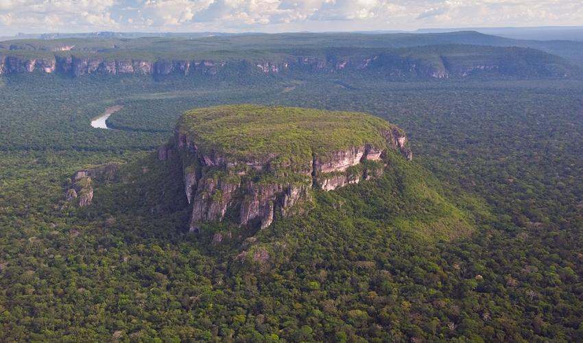
largest tropical rainforest national park in the world, and at the same time he largest national park in Colombia. the park incorporates 17.000 square miles (43,000 square kilometers) and includes the Serranía de Chiribiquete mountains, with the surrounding lowlands, covered by tropical moist forests, savannas, and rivers. The most distinguishing features of Chiribiquete are the presence of tepuis (table-top mountains), steep-sided sandstone plateau that stands alone in the rainforest, which consequence in breathtaking view. The region is incredibly rich flora and fauna and hosts a distinct range of rock art. More than 600,000 traces of over 75,000 petroglyphs and pictographs have been discovered on the walls of 60 rock shelters in Serranía de Chiribiquete, the oldest of which could date back to about 20,000 years before present time.
Atlantic Forest South-East Reserves
a South American forest that extends alongside the Atlantic coast of Brazil, and as far as Paraguay and of Argentina. Nearly 470,000 hectares, which has many rare and widespread species, is exceptionally varied when it comes to fauna and flora; in some areas one can see over 450 species of trees per hectare. Mammals (120 species), probably the largest number in Brazil. Amongst the star species are: jaguar; ocelot; the bush dog; woolly spider monkey; little “black-faced lion” monkey; and many more. Over 85% of the original area (estimated 390,000–580,000 square miles (1,000,000–1,500,000 square kilometers), that was encountered by Portuguese colonists encountered over 500 years ago, has been deforested, threatening many plant and animal species with extinction. Therefore, it is incredibly important to protect as much of the remaining area as possible.


Tyle pięknych miejsc do zwiedzania… ✈️
Ach Machu Picchu… Cudowne widoki❤️🏞️❤️
Świat jest pełen pięknych miejsc🗺️
Interesting article, keep up the good work