Last, sixth stop. Welcome to Australia and surrounded Oceania.
Great barrier Reef, Australia


this is the world’s largest coral reef system. It is established from over 900 islands, 2,900 individual reefs stretching for over 1400 miles (2,300 kilometers) over an area of roughly 133.000 square miles (344,400 square kilometers). Next to Great Wall of China, it is the second thing on earth, that is can be seen from space. The reef is a living organism, with the main structure composed and built by billions of tiny organisms, known as coral polyps. Reefs can grow in diameter by 0.39 to 1.18 inch (1 to 3 centimeters) per year and grow vertically anywhere from 0.39 to 9.84 inch (1 to 25 cm) per year; but they can grow only above a depth of 490 feet (150 meters) due to their need for sunlight. Unfortunately, the coral reefs are very vulnerable, and the climate changes is causing the reefs to bleach (which is irreversible) and die.
Tongariro National Park


This is New Zealand’s oldest national park, located on the Te Ika-a-Māui aka. North Island (together with the South Island, they are two main islands of New Zeeland). There are three active volcanos, in the center of the North Island, that is obviously are part of the park, and they are: Ruapehu, Ngauruhoe, and Tongariro. The area of the park covers many religious sites, externally important to the Māori people, which are the indigenous Polynesian people of mainland New Zealand. Tongariro National Park covers 303.5 square miles (786 square kilometers) of land. The diverse climate, from grasslands, to the top of the mountains, brings variety to plant life, as well as to the representation of animal kingdom. Peacefully living here, are 56 substantial species of birds: North Island brown kiwi, kākā, blue duck, North Island fernbird, double-banded plover, New Zealand falcon/karearea, New Zealand bellbird, morepork/ruru, grey warbler/riroriro, fantail, whitehead/pōpokotea and silvereye. The park is also a home to the only two native mammals of New Zealand. The short and long tailed bat. Also, animals introduced by Europeans, such as black rats, stoats, cats, rabbits, hare, possums, and red deer, are at home here.
Franklin-Gordon Wild Rivers National Park


The site is named after two main rivers of the area: The Franklin River and the Gordon River. The park was created, on the wave of successful campaign to protect the beautiful Franklin river from being flooded because of the project of building a dam the Gordon River in the 1980s. Part of Tasmanian Wilderness with breathtaking mountain peaks, magnificent canyons. A Lot of the Wild Rivers topography has been shaped by ancient glaciers. The area is and remote and rocky. The nature was there long before people showed up, a great example are an ancient Huon Pines that grow to an age of over 3000 years. The diverse assortment of vegetation is present throughout the terrain of the park, dominated by cool temperate rainforest, drier eucalypt forests and scenic button grass moorland. The park also contains Aboriginal historic sites.
New Zealand Sub-Antarctic Islands


Five groups of islands, in the Southern Hemisphere, located immediately north of the Antarctic region. They are integral part of New Zealand, but territorially are situated outside of the New Zealand.
Antipodes Islands: Antipodes Island, Bollons Island, the Windward Islands, Orde Lees Island, Leeward Island, South Islet.
Auckland Islands: Auckland Island, Adams Island, Disappointment Island, Enderby Island, Ewing Island, Rose Island.
Bounty Islands: Main Group, Centre Group, and Eastern Group islets
Campbell Islands: Campbell Island / Motu Ihupuku, Dent Island, Folly Island, Jacquemart Island
Snares Islands / Tini Heke: Alert Stack, Broughton Island, High Island, North East Island, Western Chain islets.
The indigenous and beautiful Subantarctic Islands are kind of forgotten paradise. They are home to about 15 species of the most bountiful and unique wildlife on earth, with many species of birds, plants and invertebrates found nowhere else in the world.
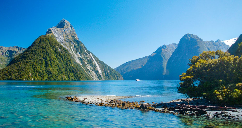
Te Wahipounamu


located on the west side, of the South Island being the territory of the New Zeeland. The site starches across 100.38 square miles (26.000 square kilometers) and including four national parks: Aoraki / Mount Cook; Fiordland; Mt Aspiring; Westland. The terrain has been shaped by consecutive glaciations into fjords, rocky coasts, towering cliffs, lakes, and waterfalls. Most of the park surface (two-thirds) is covered with southern beech and podocarps (a coniferous tree or shrub chiefly native to the southern hemisphere, widely grown as an ornamental or timber tree), some of which are over 800 years old. The kea, the only alpine parrot in the world, lives in the park, as does the rare and endangered takahe. Te Wahipounamu is home to many native animals and contains the largest and most significant population of forest birds in the country (about 170 different species). Kakapo (the world rarest and heaviest parrot) was seen here still in 1980s, while it is considered extinct on the rest of the land. Also living here: Southern Brown Kiwi, Great Spotted Kiwi, Yellow-crowned parakeet, Fiordland Penguin, New Zealand Falcon, and Brown teal. Along the coast New Zeeland Fur Seals found their place.
Shark Bay, Western Australia


situated approximately 500 miles (800 kilometers) north of Perth, in Australia. 8.900 square mile (23,000-square-kilometre) range serves as a protected space for pristine marine life. 30 feet (9 meters) deep, with over 930 miles (1500 meters) of coastline, with a portion of it being overlooked by tall limestone, rocky cliffs (span for 190 miles – 300 kilometers). Shark Bay is incredibly important site, from the life formation perspective. The site is mostly recognized for immensely important existence, in a great numbers, of stromatolites (colonies of microbial mats that form hard, dome-shaped deposits which are said to be the oldest life forms on earth). The sea bottom is covered with one of the largest and most diverse seagrass beds in the world. The property is also famous for its rich marine life including a large population of dugongs (sea cow’s) and provides a refuge for several other globally threatened species.
Tasmanian Wilderness


This site is one of the largest conservation areas in Australia, covering 6.10 square mile (15,800 square kilometers), that is make it almost 20% of Tasmania region. It is a home of one of the last expanses of temperate wilderness in the world, which basically are (Wilderness or wildlands) natural settings on Earth that have not been substantially modified by human activity or any nonurbanized land not under extensive agriculture, nature in its purest form. Frequently these areas are believed to be essential for the survival of specific species, biodiversity, conservation studies, and conservation. They may also preserve historic genetic traits and provide habitat for wild flora and fauna that may be difficult to find anywhere else.
Jenolan Caves


The complex of limestone caves in the heart of the Blue Mountains, located in Eastern Australia, are one of the world’s most spectacular cave formations. The caves are surrounded by 7,620-acre (3,083-hectare) reserve, that is only adds to the beauty to this place. The caves are important heritage site to the indigenous people (Gundungurra and Wiradjuri peoples) living there. The cave network follows the path of an underground section of the Jenolan River. It runs for more than 25 miles (40 kilometers) of multi-level passages and over 300 entrances. Many of the caves are open to the public, even though the complex is still being studied. One of the spectacular highlight of the caves, highly noted for their beauty, are the calcite formations, in some spots pure white in color, that is creates unbelievable looks.
Ball’s Pyramid


situated southeast of Lord Howe Island in the Pacific Ocean, over 400 miles (643 kilometers) northeast of Sydney. The ball’s Pyramid is a remnant, the last piece, remaining of the cauldron like volcano site, shortly after eruption. It was formed approximately 6.4 billion years ago. It is 1844 feet (562 meters) high, while being only 3,609 feet (1,100 meters) in length and 984 feet (300 meters) across, making it the tallest volcanic stack in the world. It was named after named Lieutenant Henry Lidgbird Ball (of Royal Navy) in 1788, who discovered it, during his voyage (It is claimed that during the same trip, Ball also discovered Lord Howe Island).
Purnululu National Park


This Park is found in the Kimberley region, which takes up the entire north-west corner of the Australian continent. The 592,370-acre (239,723-hectare) terrain of The Bungle Bungle Range (also called the Bungle Bungles) was the location only known to local Aboriginals and shepherds. It was presented to the world’s public attention in 1983. They were formed more than 350 millions years ago. It is a dazzling landscape of modelled rocks rising 820 feet (250 meters) above the surrounding semi-arid savanna grasslands and the most outstanding example of cone shaped karst mountain formation in sandstone anywhere in the world. Today this maze of orange and black striped (The orange, grey and black stripes are the result of alternating bands of residue, each with different clay content) sandstone domes, often compared to giant beehives, are immensely popular tourist attraction.
Sydney Opera House

This is no doubt, one of the most recognizable buildings, created in 20th century. Located in harbor in Sidney. After 16 years of construction, the opera house was finally open on 20 October 1973; the opening ceremony was performed by Queen Elizabeth II. The building constructed with the idea of multipurpose use. The multiple venues inside, includes: Concert Hall; Joan Sutherland Theatre; Drama Theatre; Playhouse; Studio; Utzon Room (private party room); Recording Studio; Outdoor Forecourt. The Total amount of the seats, homed by the opera house, comes to astounding number of 5,738.
Macquarie Island


lies in the Southwestern Pacific Ocean, about halfway between New Zealand and Antarctica. Regionally part of Oceania and politically a part of Tasmania, Australia. It was discovered, on 11 July 1810, by Frederick Hasselborough, an Australian. He was the one, who came upon completely uninhabited island. He claimed the newly unearthed island for Britain and annexed it to the colony of New South Wales in 1810. The island was named for Colonel Lachlan Macquarie, Governor of New South Wales (1810 to 1821). Macquarie Island is about 21 miles long (34 kilometers) long and 3 miles (5 kilometer) wide, with an area of 49 square miles (128 square kilometers). They are two highest points on the island: Mount Elder on the north-east coastal ridge at (385 meters – 1,263 feet), and Mounts Hamilton and Fletcher in the south at (410 meters – 1,345 feet). There is a rich fauna on the island, mainly sea mammals and birds: subantarctic fur seals, Antarctic fur seals, New Zealand fur seals, southern elephant seals, orcas, sperm and beaked whale, Royal penguins, Macquarie shags, king penguins, southern rockhopper penguins and gentoo penguins. the island has no permanent residents, except few members of the geological and meteorological research stations (since 1948), which means that is the animals are fully in control here.
Rock Islands Southern Lagoon


Rock Islands of Palau covers nearly 100,200 ha and stretches over 445 uninhabited limestone islands created by the volcanic activity of the region. Many of them have this distinctive mushroom-like shapes, scattered across turquoise lagoons, surrounded by coral reefs. The visual magnificence of the site is enhanced by an intricate reef system featuring over 385 coral species and different types of habitat. The islands sustain a large variety of plants, birds and marine life including dugong (sea cows) and at minimum thirteen shark species. The spot protects the highest concentration of marine lakes (isolated bodies of seawater separated from the ocean by land barriers). They are one of the main characteristics of the islands. The remains of stone walls villages, together with the burial sites and artwork painted on the rocks, bring an evidence about organization of the communities on small islands, over some three millennia.
Wooroonooran


located in wettest part of Australia (which gets the highest rainfall, across the whole country), Queensland. The park incorporates large portion of Bellenden Ker Range (also known as the Wooroonooran Range is a coastal mountain range in Far North Queensland) and includes Queensland’s two highest mountains: Mount Bartle Frere (5321.5 miles – 1622 meters) and Mount Bellenden Ker (5223 feet – 1592 meters). Walshs Pyramid at (3025 feet – 922 meters) in height, is a free-standing pyramid mountain, not directly connected to any mountain range. The park, as well features beautiful waterfalls, among the rocky valleys. Rainforests in the park are home to more than 500 different tree species. The high-altitude forests areas allow Australia’s only native species of rhododendron, to grow tall and undisturbed. The park supports immensely rich bird population, living in the branches of rainforest.
East Rennell


This island lays on the Southern portion of Rennell Island, which belongs to the complex of Solomon Islands. The Rennell is known for being the largest coral Atoli (the circle of coral reef around the island), and there is a body of water, Lake Tegano (also known as Te Nggano) in the center of it. The island is covered with lush, thick green forests. The island has about 800 permanent residents, living in small villages, surrounding the center located lake. They are fishing locally and using the rich waters and the plentiful of fish, they can support themselves and their families. The island is providing habitat for the many bird species. Fifty species of bird have been recorded on the island, twenty-one of these being more widespread.
Nan Madol: Ceremonial Centre of Eastern Micronesia


The name Nan Madol means “within the intervals” and is a reference to the canals that crisscross the ruins. The archaeological site lays in the district of Pohnpei state in the Federated States of Micronesia. The city was formed in a lagoon, that involves of a chain of small islands (artificially created) linked by elaborate network of canals. The area of approximately 0.93 by 0.31 miles (1.5 by 0.5 kilometers) was a heart of the location. Nearly 100 stone and coral fill platforms (serving as the artificial islands) fringed by tidal canals, and finally surrounded by the stone wall, creating unify secure terrain. Nan Madol was the ceremonial and political seat of the Saudeleur Dynasty, which united Pohnpei’s estimated population of 25,000 people until about 1628. The site was a special place of residence for the nobility and of mortuary activities led over by priests. Its population reached about 500 residents. It is believed by the archaeologists, that is the monolithic structures, were built about 12th century.


Nice one Bro.. Very interesting. Can you please help me out and tell which theme you are using and which theme you are recommended to a new blogger.
Thank you.
thanks. first of all, quite the Bro thing!. im not a guy!! choosing a theme, is a subjective thing. looks what you like. every hosting platform, your host platform have free themes, so check them out, and just look for one that you like, then you can install it to your site. hope thats helps.